Advancing active mobility in greater Prince William, Virginia

Category: PW BOCS (Page 2 of 3)

Active Prince William’s Initial Comments on the Proposed Design of the Route 234-Brentsville Road Interchange

 
PROBLEM:
Forcing bicycle and pedestrian users to cross FOUR separate free-flowing, high-speed vehicle lanes is an unacceptable way to connect two of the major trails in the county.  The section should be removed from the design.  It is too dangerous.  [Added Note: The proposed design forces bicyclists and pedestrians to negotiate a fifth high-speed at-grade road crossing (of the ramp from northbound Brentsville Road to southbound Route 234) to actually link these two major trails.  Furthermore, to access or egress Route 234 Business/Dumfries Rd, bicyclists and pedestrians would be forced to negotiate a sixth high-speed at-grade road crossing plus 12 vehicle lanes at two controlled intersection legs at Bradley Cemetery Way.]


RECOMMENDED SOLUTION:
Add an additional bike/ped bridge crossing of Route 234 south/east of the planned interchange to directly and safely connect the Route 234 Trail and the Prince William Parkway Trail.


HOW TO PAY FOR THIS RECOMMENDED SOLUTION:
1) Remove the proposed bike/ped infrastructure with four at-grade roadway crossings from the Bradley Cemetery Way area:

2) Change the Continuous Green-T Intersection at Brentsville Road and the off-ramp from VA234 Bypass South to a Roundabout, Standard Two-Phase Traffic Light or a Three-Way Stop Sign.  Future traffic volumes do not warrant the expensive infrastructure needed for a Continuous Green-T Intersection.

3)  Remove one northbound lane from the planned Brentsville Road Bridge to create a smaller/cheaper bridge footprint.  Future traffic volumes do not warrant having two northbound vehicle lanes on this bridge.

Environmental and Social Injustice in Prince William County–In 2021. Yes, 2021.

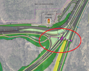
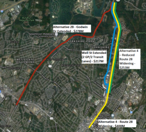
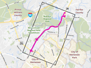
Proposed Route 28 Bypass Alignment (as of February 2021)

Remember the bad old days, when government officials routed new highways through minority neighborhoods and displaced low-wealth families for the benefit of more-wealthy White drivers?

Well, it’s happening right now in Prince William County.

To construct the Route 28 Bypass/Godwin Drive Extended, County supervisors would tear down more than 50 homes in a low-income and heavily Hispanic neighborhood.  At least three families in the Bull Run Mobile Home Park would have to move.  The entire mobile home park could close and be replaced by a mixed-use development with much higher rents/mortgage payments.

The losers:  those living in a rare affordable community in Northern Virginia.  The beneficiaries:  commuters from Fauquier, Culpeper, Stafford, and beyond driving to high-paying jobs in Fairfax and DC.

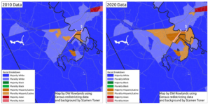
Racial Characteristics of Census Tracks Surrounding the Route 28 Bypass Alignment (pink line).

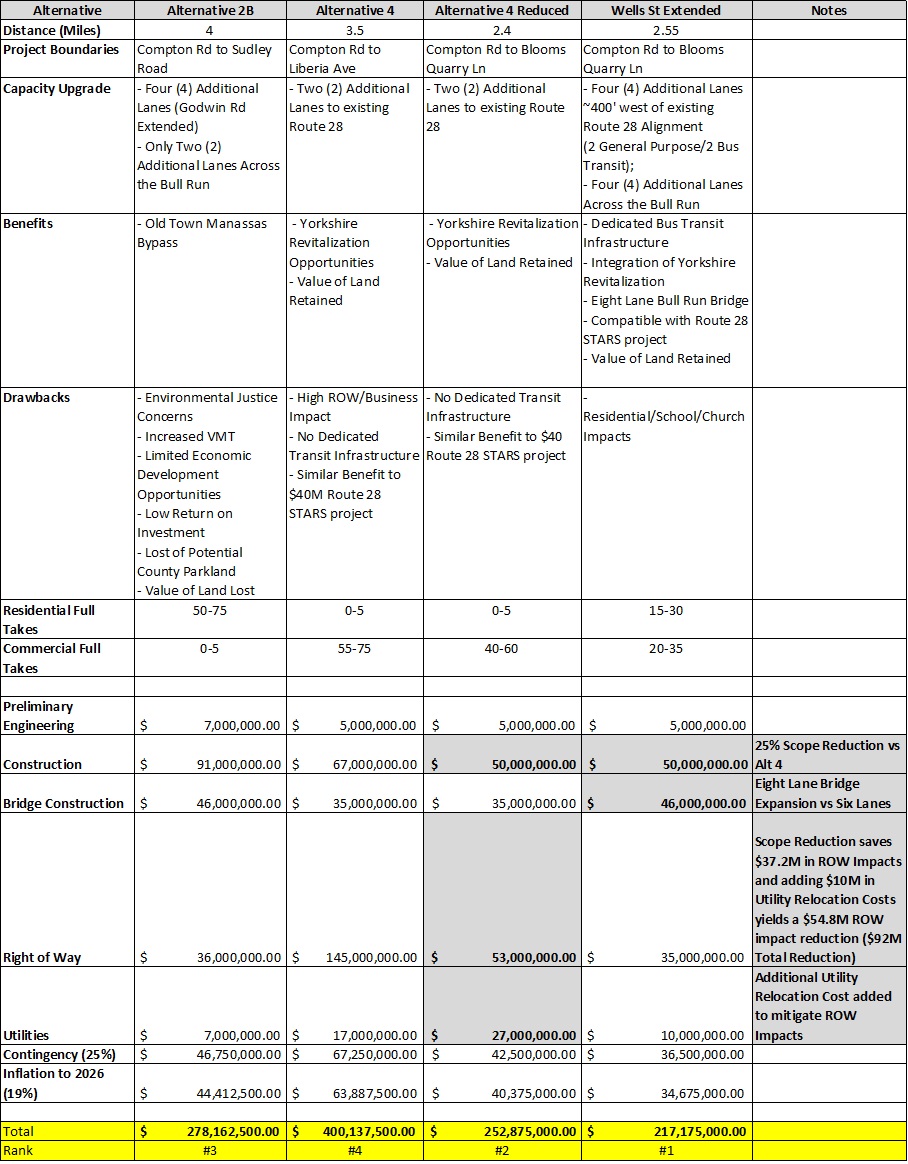
Building the Route 28 Bypass would cost at least $300 million, not counting the widening of the adjoining stretch of Godwin Drive in the City of Manassas, estimated in 2019 to cost more than $40 million.   Prince William taxpayers would provide $200 million in funding through a County bond issue.  It’s a government subsidy for exurban drive-alone commuters, few of whom would be traveling to jobs in the County or increasing the local commercial tax base.

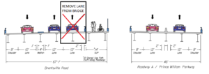
The Route 28 Bypass would poorly serve commuters.  The Bypass would significantly worsen traffic congestion and travel times on Route 28 in Centreville,  compared to its “No-Build Alternative”, and includes no accommodations for efficient bus transit or managed lanes, such as high-occupancy vehicle (HOV) or high-occupancy toll (HOT) lanes, to reduce single-occupant vehicle (SOV) trips.

The equity issue is most relevant today.  The neighborhoods being destroyed are designated Equity Emphasis Areas.  They have been stable, affordable communities for Hispanic residents.  Carving up communities occupied by minority groups, for the benefit of those fortunate to have high-paying jobs closer to DC, is a modern version of environmental injustice.

Oh, and the commuter road would blast through Bull Run Regional Park and the Flat Branch stream valley.  If the noisy and polluting Route 28 Bypass highway barrier isn’t built, the Flat Branch stream valley could become a wonderful linear park and natural habitat that significantly enhances the livability and bike/ped connectivity of its adjacent neighborhoods.  After Prince William voters approved the road-expansion bonds in 2019, County officials cancelled an Environmental Assessment, to avoid examining alternative routes with fewer environmental and social impacts

There’s a chance to stop this environmental and social injustice.  Prince William County supervisors will approve a capital budget by June, 2022 which could include funding for the Route 28 Bypass–or they could instead allocate $200+ million in local funds over the next twenty years to other projects, such as affordable housing, and not repeat the injustices of the 1950s.

For the County’s sales job, see https://route28bypass.com.  For the rest of the story, see the Active Prince William website at https://www.activepw.org.

Active Prince William is a group of concerned citizens who advocate for better opportunities, support, and infrastructure for active mobility, better public transportation, and healthy lifestyles within Prince William County, Manassas, and Manassas Park.  We are working to help make Prince William County and Greater Manassas a more livable, healthy, equitable, and sustainable community.   Follow us at https://www.activepw.org/ , @Active_PW on Twitter, and ActivePW on Facebook.

Our Recommendations for Upcoming NVTA Transportation Funding Applications from PWC

On July 19, 2021, Active Prince William sent the following email message to the Prince William County Planning Commission, which will soon be briefed by County transportation staff on the transportation projects that the County is considering for submission to the Northern Virginia Transportation Authority (NVTA) in Fall 2021 for  potential regional funding .  Various local transportation and elected officials, including the Prince William Board of County Supervisors, were copied on this message.


Active Prince William supports the integration of land use, housing, and transportation planning.  Having the Transportation Department brief the Commission on planned grant applications is a start.  That step should be followed by a formal public hearing and a vote of the Planning Commission.

New mobility infrastructure should substantially enhance the transit and bike/pedestrian network, rather than simply expand the road network and add a desolate side path.  Traditional “business as usual” planning for the next decade will sabotage the county’s commitment to reduce greenhouse gas emissions by 2030 to 50% of the 2005 levels.  The transportation sector generates the greatest amount of greenhouse gas emissions in Prince William now.  The only way to meet the 2030 target is to reduce the carbon spewing from tailpipes in Prince William, and that requires a new approach to planning for multimodal *mobility* and access, rather than just paving more roads for drive-alone motorists.

In 2030, most cars will still be fueled by gasoline.  Virtually every project that paves more lane miles will increase Vehicle Miles Traveled (VMT) and greenhouse gas emissions from those cars.  To understand the impact of various proposed projects, the Planning Commission should identify the projected increase in VMT associated with each transportation project, and use that data when determining which projects to recommend to the BOCS.

The Planning Commission recommendations to the BOCS should be guided by the Strategic Plan.  The Strategic Plan calls for the County to develop in a sustainable way.  As you know, new transit and bike/pedestrian projects have the potential to reduce or minimize VMT and associated greenhouse gas emissions.  To be sustainable, the County must abandon the old school approach of just building more roads–and acknowledge that more roads have not reduced traffic congestion.

For the upcoming NVTA grant program, Active Prince William recommends submitting the following projects to the next NVTA funding round (FY26/FY27). As you can see, none of these projects’ main intent is to add lane miles.  All projects support Transit, Active Transportation, and/or Intersection/Interchange improvements.

  • Route 1/Potomac Mills BRT (TRANSIT) – NVTA 38/39
  • Dale Blvd Improvements (TRANSIT) – NVTA 241
  • VRE Second platforms – Manassas Line (TRANSIT) – NVTA 300
  • I-95 Ped/Bike Crossings (TRAILS/ACTIVE TRANSPORTATION) – NVTA 300/242/49/241
  • Balls Ford Road/I-66 Trail Improvements (TRAILS/ACTIVE TRANSPORTATION)  – NVTA 50
  • Route 123 Improvements (INTERCHANGE/INTERSECTION IMPROVEMENT) – NVTA 242
  • Wellington Rd/Sudley Manor/VA234 Interchange Improvements (INTERCHANGE/INTERSECTION IMPROVEMENT) – NVTA 222
  • Minnieville Rd/PW Parkway Interchange (INTERCHANGE/INTERSECTION IMPROVEMENT) – NVTA 279
  • Pageland Ln/Sanders Ln Safety Improvements (INTERCHANGE/INTERSECTION IMPROVEMENT) – NVTA 227
  • Route 28 STARS (INTERCHANGE/INTERSECTION IMPROVEMENT) – NVTA 29/32

Many of these projects do not match exactly with the NVTA Transaction description but the NVTA has set a precedent by funding innovative intersection improvements at University Boulevard and Prince William Parkway even though NVTA Transaction clearly requires “Construct Interchange at Prince William Parkway and University Boulevard.” (NVTA 324).  Active Prince William agrees with this approach as the intent of the projects is to improve the specified transportation segment.

Below is the list of projects that were not funded in the previous NVTA funding round (FY24-FY25).   As you can, see most of these projects’ main intent is to add lane miles that will induce new VMT and future congestion.  We need to stop advancing projects that continue to increase car dependency and have long-term adverse impacts on the climate and county budget.

  • Van Buren Road North Extension: Route 234 to Cardinal Drive (NEW ROADWAY)
  • Construct Route 28 Corridor Roadway Improvements (NEW ROADWAY/BYPASS)
  • University Boulevard Extension: Devlin Road to Wellington Road (NEW ROADWAY)
  • Wellington Road Widening: University Boulevard to Devlin Road (ROAD WIDENING)
  • Devlin Road Widening: Linton Hall Road to Relocated Balls Ford Road (ROAD WIDENING)
  • Route 234 and Sudley Manor Drive Interchange (INTERCHANGE/INTERSECTION IMPROVEMENT)
  • Prince William Parkway at Clover Hill Road Innovative Intersection (INTERCHANGE/INTERSECTION IMPROVEMENT)
  • Prince William Parkway at Old Bridge Road Intersection Improvements (INTERCHANGE/INTERSECTION IMPROVEMENT) | Funded via Smart Scale

###

APW Urges Its TPB Members to Ensure New Transportation Plans Meet Climate and Equity Goals


On June 15, 2021–in advance of the June 16 meeting of the National Capital Region Transportation Planning Board (TPB) at which the project submissions for updating Visualize 2045, the region’s long-range transportation plan, were scheduled for adoption –Active Prince William sent the following message to Prince William County’s two representatives on that regional transportation planning body–Prince William Board of County Supervisors Chairman Ann Wheeler and Neabsco District Supervisor Victor Angry.   We also sent similar messages to the TPB members who represent the Cities of Manassas and Manassas Park–Manassas Vice Mayor Pamela Sebesky and Manassas Park Mayor Jeanette Rishell.

Here’s a summary of the contentious June 16, 2021 TPB meeting, at which a proposal to craft a climate-friendly regional transportation plan for adoption  by 2024 was agreed to


The National Capital Region Transportation Planning Board (TPB) will be taking up a resolution at their June 16th meeting regarding a Visualize 2045 Alternative Build Scenario that would aim to achieve TPB climate and equity goals through the use of transportation demand management, transit, and land use strategies consistent with regional policy goals, a modified regional project list that reduces the number and scale of road capacity expansion projects in accordance with anticipated reduced travel demand, and with particular focus on public transportation and pedestrian/bicycle improvements needed to serve mobility disadvantaged populations.  This is being brought forward because the recently submitted project updates to Visualize 2045 will not meet the TPB climate and equity goals.

Due to the time and resource constraints at this point in the Visualize 2045 update process, Active Prince William recommends Prince William County support the following action plan to support meeting TPB climate and equity goals:

1)    Commit to completing the TPB Climate Change Mitigation Study and review it thoroughly at the regional and jurisdictional levels through the first quarter of 2022.

2)    Formally commit to assisting the TPB to develop a set of transportation policies and projects, by the end of 2022, which would be implementable at the jurisdictional and regional levels, consistent with the recommendations of the Climate Change Mitigation Study, that, when fully implemented will assure the region will meet its climate change mitigation goals

3)    Commit to take actions to officially adopt the projects and policies developed to attain the region’s climate goals within the transportation sector, and advance these projects into the region’s LRTP for a mid-term update to be completed in 2024

As voting members of the TPB, this is an opportunity for Prince William County to be a transportation planning leader as it relates to climate and equity in the region.   Supporting this initiative aligns with PWC BOCS Resolution 20-773: Regional Climate Mitigation and Resiliency Goals and the Prince William County Equity and Inclusion Policy.

The updated mobility chapter of the comprehensive plan should be aligned with this action plan.  Prince William County should also advocate these measures be included as the starting point for the next NVTA Transaction Plan.  To support this the Prince William County should advocate that the General Assembly act to modify the NVTA statute to align with your climate and equity goals.

The climate is not waiting. The time to act is now.

The Route 28 Manassas Bypass Is Not the Lowest Cost Or the Least Environmentally Damaging Practicable Alternative (LEDPA) for the Route 28 Corridor

The Alignments of the Four Route 28 Corridor Expansion Alternatives Compared Below

Active Prince William board member Mark Scheufler sent the following comparison of Route 28 corridor alternatives to the Prince William Board of County Supervisors on November 30, 2020.


Dear Prince William Board of County Supervisors:

In advance of the December 7th  virtual public meeting on Route 28, it is timely to correct misinformation about the alternatives to Alignment 2B. The costs of Alternative 4 (Widening Route 28) were overstated by calculating the impacts/costs of widening Route 28 between Blooms Quarry Lane and Liberia Ave that is already six lanes.

Realistic cost estimates are needed not only by the supervisors in Prince William and Fairfax counties, but also by the US Army Corps of Engineers and the Virginia Department of Environmental Quality.  Those two agencies may determine that cost differences between Alignment 2B and other alternatives are not sufficient to justify the greater environmental damage.

As the Meeting Minutes at the January 16, 2020 Project Update and Alternatives Development Technical Memo Review  state (on pages 2 and 3):

“Stuart ended with a presentation of the cost summary for the alternatives, which showed that Alternative 4 would be almost $100 million more than Alternatives 2A and 2B. MacKenzie indicated that cost would not be a factor that the Department of Environmental Quality (DEQ) would consider in their evaluation. Rick responded that he understood, but emphasized the need to consider purpose and need in the comparison of the alternatives.

Subsequent to the meeting, Hannah Schul, DEQ, clarified that DEQ makes permitting decisions based on the Least Environmentally Damaging Practicable Alternative (LEDPA). Per the Clean Water Act, a permit cannot be issued if a practicable alternative exists that would have less adverse impacts on the aquatic ecosystem. The LEDPA does take cost into consideration, but an alternative would only be potentially eliminated if costs are clearly exorbitant compared to similar alternatives.”

The analysis summarized in the table below [the complete ROW analysis is here] shows the cost of alternatives along or near existing Route 28 are not exorbitant compared to Alternative 2B.   Alternative 4 includes $37M in ROW impacts along a 1.1-mile section of Route 28 that is already six lanes and should require minimal improvement and no ROW impacts (Blooms Quarry Lane to Liberia Ave).  An additional $54M* in Alternative 4 ROW impacts could be mitigated by increasing the Utility Relocation Costs ($10M).  These modifications would bring the Alternative 4 cost estimate below Alternative 2B.  But implementing the Route 28 STARS recommendation and the Well St Extended recommendation  is the best alternative for the Route 28 corridor to meet transit, revitalization, and climate goals and is the cheapest alternative.  The Well St Extended recommendation was not included in the original set of alternatives because transit, revitalization and climate were not considered part of the project purpose and need.

A Comparison of Four Route 28 Corridor Alternatives (click on the image above to enlarge for reading)

Alternative 2B is not the Least Environmentally Damaging Practicable Alternative (LEDPA) and may not receive permits to move forward.  Creating a regional park along this alignment is the best use of the land in the flood plan.

*8300 CENTREVILLE RD, 8130 OAK ST, 7901 CENTREVILLE RD

If you need any clarification, please let me know.

Thanks,

Mark Scheufler

PWC Resident

« Older posts Newer posts »