![]()
Category: Sidewalks (Page 2 of 3)
1) Establish Citizen Transportation Advisory Commissions for Prince William County, Manassas, and Manassas Park.
2) Provide Meaningful and Robust Public Participation Processes for the Coming Comprehensive Plan Updates for the County and Cities.
3) Expand and Enhance Public Transportation as an Effective Travel Choice:
a) Add midday, evening, and reverse-commute VRE trips, possibly as shortened runs to/from Alexandria and/or Springfield/Franconia.
b) Add local and commuter bus service along Rte 28 and Sudley Rd, ideally in dedicated lanes.
c) Extend Richmond Hwy BRT south through Prince William County along the Rte 1 corridor to Quantico.
4) Build Complete Streets, especially a Primary Bikeway Network that Crosses Major Barriers (e.g., rivers, freeways, land parcels):
a) Build a continuous “I-66 Trail”, largely along Balls Ford Rd and across Bull Run into Fairfax County.
b) Build a quality bike/ped crossing of I-66 at or near Sudley Rd/Bus 234. In short term, ensure space for paths beneath all new I-66 overpasses of Sudley Rd.
c) Retrofit quality bike/ped crossings of I-95, especially at/near Prince Wm Pkwy/Horner Rd and at/near Dale Blvd/Opitz Blvd, but also at/near Rte 123, 234, & Joplin Rd.
d) Complete a continuous trail along Rte 234, from Rte 1 to I-66, including the totally missing segment between Brentsville Rd and I-66.
e) Include quality bike/ped access along and across Flat Branch and Bull Run in the proposed Godwin Dr Extension (Rte 28 environmental assessment).
f) Improve US Bike Route 1, a Maine-to Florida bikeway: Retrofit paved shoulders along Aden Rd (Joplin Rd to Fleetwood Dr) and Fleetwood Dr (Aden Rd to Fauquier line), fix the Hoadly Rd bike lanes, and sign all of USBR1 in PWC. Plan and create a paved shared-use path along the perimeter of Quantico Marine Corps Base as a long-term project.
g) Improve bike/ped crossings of Bull Run and the Occoquan River, including at Old Centreville Rd/Ordway Rd, Rte 28, Yates Ford Rd, I-66 Trail (connect Balls Ford Rd to Bull Run Dr), and Rte 1.
h) Improve bike/ped access along the Rte 29 corridor (Bull Run to Fauquier line).
i) Establish continuous ped/bike access along Old Bridge Rd.
j) Plan and develop a bikeway and trail network in Manassas Park.
5) Develop Livable, Walkable, and Vibrant Transit-Oriented Communities:
a) Plan to revive aging suburban retail corridors and malls for higher-density, mixed-use, bus-transit-oriented redevelopment (e.g., Manassas Mall and the Sudley Rd corridor, Rte 28 in Yorkshire, Rte 1, Dale Blvd, Old Bridge Rd).
b) Remove or scale back all or part of numerous proposed road widenings from the Comprehensive Plan, including Brady’s Hill Rd, Carver Rd, Catharpin Rd, Dale Blvd, Dumfries Rd, Farm Creek Dr, Featherstone Rd, Gideon Dr, Godwin Dr Extension, Gordon Blvd, Groveton Rd, Gum Springs Rd, Horner Rd, Lucasville Rd, Manassas Battlefield Bypass, Neabsco Rd, Old Centreville Rd, PW Pkwy, Signal Hill Rd, Station Rd, Sudley Manor Dr, Sudley Rd, Rte 15, Rte 29, Rte 55, and Wellington Rd.
c) Innovation Town Center: Plan and develop a robust pedestrian and bicycle network, including a high-quality connection to the north side of the expanded Broad Run VRE Station.
6) Operate a Vibrant Safe Routes to School Program:
a) All new public schools, including the 13th high school, should be walkable and bikeable and include quality bicycle parking accommodations.
7) Make Walking and Bicycling Safer:
a) Improve pedestrian crossings of multilane arterials (e.g., add missing pedestrian crossing signals, Leading Pedestrian Intervals, conspicuously marked crosswalks, sidewalk bulb outs, and/or streetlights; remove Right-Turn-Only Lanes).
b) Retrofit missing sidewalks along arterial roadways and on walk routes to schools and transit.
c) Provide a signed detour when pedestrian or bicycle facilities are closed for construction or maintenance activities.
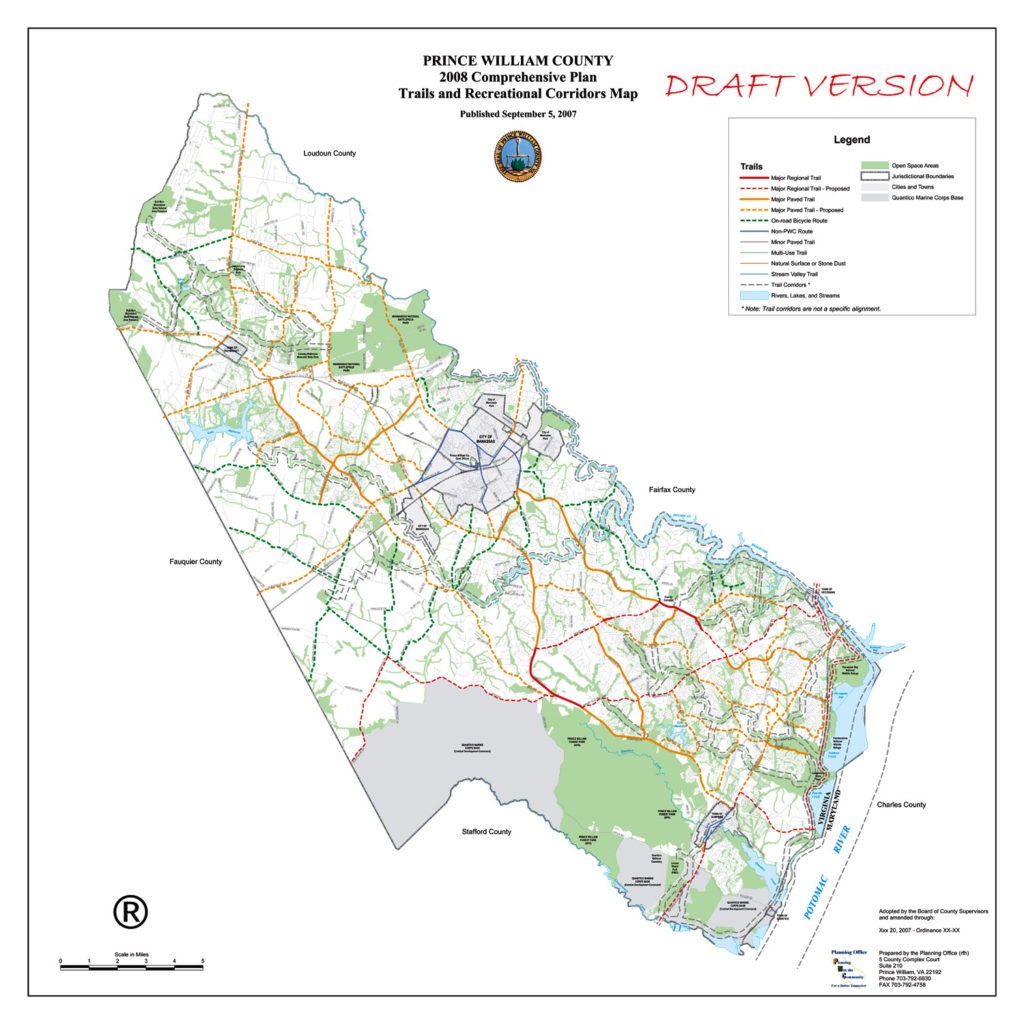
8) Build a Comprehensive Recreational Trails Network:
a) Complete the East Coast Greenway/Potomac Heritage National Scenic Trail shared-use path through PWC, generally between Rte 1 and the Potomac River.
9) Improve VRE Bicycle Access:
a) Provide covered bicycle parking and rental bicycle storage lockers at every VRE station in Prince William County, Manassas, and Manassas Park.
b) Improve bike/ped connections to VRE stations from all directions, including the expanded Broad Run station (including the Broad Run Trail), to improve bike/ped access to VRE from Bristow, the Landing at Cannon Branch, and Innovation Town Center.
c) Expand VRE bike-on-rail access (long capped at 34 bikes on 17 daily trains).
10) Provide Ubiquitous, Quality Bicycle Parking Accommodations.
Content derived from http://manassascity.org/2431/Comprehensive-Plan-Update
Using an 18-month process, the City of Manassas will update its Comprehensive Plan–the City’s key policy document for land use, development, preservation and related economic and social issues. As part of that update, the City will also develop its first Transportation Master Plan to guide future transportation investments and improve mobility in the City. This is an exciting time for City residents as the Manassas community envisions its future!
Citizen input in updating the Comprehensive Plan is vital to a more livable Manassas. Throughout the summer and fall, the City will host a second round of Community Conversations on key topic areas, like land use and transportation. These conversations began on June 19th with a visioning session on land use. Additional meetings are scheduled throughout the summer and fall. City Staff will also be available to meet with neighborhood and community organizations to gather feedback. Please contact 703-257-8223 for more information about hosting a meeting.
Upcoming Meetings
Parks & Recreation Community Conversation
hosted by the Parks & Recreation Committee
Wednesday, July 11th – 7 PM @ Manassas Museum, 9101 Prince William Street
Community Appearance & Environment Community Conversation
hosted by the Manassas Beautification Committee
Thursday, July 19th – 7 PM @ Public Works, 8500 Public Works Drive
Economic Development Community Conversation
hosted by the Manassas Business Council
Thursday, August 2nd – 12 PM @ Centerfuse, 9071 Center Street
Infrastructure Community Conversations
hosted by the Utility Commission
Thursday, August 9th – 7 PM @ Public Works, 8500 Public Works Drive
Culture & Historic Resources Community Conversation
hosted by the Historic Resources Board
Tuesday, September 4th – 7 PM @ Manassas Museum, 9101 Prince William Street
Community Conversation Town Hall
hosted by the Manassas City Council
Monday, September 17th – 7 PM @ Location TBA
Past Meetings
Comprehensive Plan Kickoff & Community Conversation on Land Use
hosted by the Planning Commission
Tuesday, June 19th– 7 PM @ Boys and Girls Club, 9501 Dean Park Ln.
Land Use Community Conversation Meeting Materials
Land Use Community Conversation Presentation
Additional Resources
Community Conversations Phase 1
View coverage of the Community Conversations Kick Off meeting:
Please visit www.manassascity.org/planmanassas for additional information and additional meeting dates.
Meeting Address: 9444 Taney Rd # 100, Manassas, VA 20110
http://www.manassascity.org/grantave
Grant Avenue Streetscape Plan


Share your ideas and vision to help improve the appearance of Grant Avenue. Planning efforts will focus on improving Grant Avenue from Lee Avenue to Wellington Road.
See the June 29 first meeting Presentation
View Meeting Exhibits with Public Comments:
Streetmix Sections
Want to keep informed about the Grant Avenue Streetscape Plan?
Sign up for emails or messages
Call 703-257-8232 for more information.
As part of the ongoing Comprehensive Plan update, the Prince William County Planning Office has created several small area plans to guide development in key areas of the county. Each small area plan may offer opportunities for improved transit, increased open space, and greater walkability.
Public outreach will be accomplished through one or more public meetings and design charrettes for each project. A charrette is a collaborative planning session among a project’s various stakeholders – in this case, government officials, consultants and/or developers, and interested members of the public. A planning outline and some anticipated outcomes are provided for each active plan at the links below. There are no upcoming public hearings or charrettes currently scheduled, but the Planning Department promises to update the website when they have been. We will monitor the website as well.
Five plans that are currently active:
Dale City
The basis for this project is two studies completed earlier this year: one by the Dale City Sustainable Design Assessment Team (SDAT) and the other under a Metropolitan Washington Council of Governments (MWCOG) Transportation/Land-Use Connections (TLC) Program grant. The scope of the studies includes redevelopment of both the Dale Boulevard/Minnieville Road intersection and Mapledale Plaza at the intersection of Dale Boulevard and Queensdale Drive, as well as extensive redesign of vehicular, cycling, and walking infrastructure throughout the area.
Innovation Park
An examination of the Innovation Park area and a couple of miles of Prince William Parkway between Sudley Manor Drive and Godwin Drive/Nokesville Road, with the goal of developing Innovation Park as an economic center for PWC.
North Woodbridge
Covers US-1 between Occoquan River and Occoquan Road, north to I-95 and south to Belmont Bay Wildlife Refuge. The major issues appear to be the US-1/VA-123 interchange and multi-modal transportation options. There is currently very little usable infrastructure for non-motorized traffic in this area.
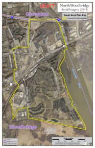
Small Area Plan: North Woodbridge
Parkway Employment Center
An update of the existing Parkway Employment Center sector plan at I-95/Horner Road/Prince William Parkway. A .pdf of the 2008 sector plan is available here.
Route 29
There is not a lot of information available for this plan yet. It will include a bike path along US-29 between US-15 and Somerset Crossing.
Future SAP projects include Independent Hill, Triangle, Yorkshire, and Fairgrounds/New Dominion.
Ryan Foster ([email protected]), Community Development Manager, and David McGettigan ([email protected]), Long-Range Planning Manager, are the primary points of contact for questions or comments.
Active Prince William is a group of concerned citizens who advocate for improving opportunities, support, and infrastructure for active transportation and healthy lifestyles within Prince William County, Manassas, and Manassas Park. We are interested in helping to make Prince William County and Greater Manassas a more livable and sustainable Community.