Advancing active mobility in greater Prince William, Virginia

Tag: City of Manassas (Page 2 of 2)

City of Manassas Transportation Project Virtual Public Meetings, May 18, 20, and 25

During May 2021, the City of Manassas held three virtual public meetings on various transportation projects:

1) Tuesday, May 18 @ 7 pm–virtual public meeting on the Sudley Road Third Lane project . View the project design presentation on the Sudley Road Third Lane Project from the May 18 meeting.

2)  Thursday, May 20 @ 7pm–virtual public meeting on four sidepath projects (Godwin Dr, Dumfries Rd, Gateway Blvd, and Wellington Rd trail gap) and three sidewalk projects (Portner Ave, Quarry St, and Gateway Blvd).  View the meeting presentation and a 31-minute recording of the Zoom meeting.

3) Tuesday, May 25 @ 7pm–virtual public meeting on the Dean Drive Extension ProjectView the project design presentation on the Dean Drive Extension Project.

City of Manassas Installs Dangerous and Unnecessary Trail Bollards

March 15, 2021 Update:  We have  been informed by the City’s Director of Public Works that many of the bollards shown below have been removed.  The City is now installing a single rigid bollard on the trail centerline, with additional bollards placed six feet apart at some locations.  In addition, reflective tape will be installed near the top and the bottom of each bollard.  While these changes significantly reduce the severity of the trail-bollard hazard, the users of these paths will still remain at some risk for serious and permanently debilitating and even fatal injuries from crashing into the remaining bollards.  We urge all public agencies to heed the AASHTO guidance and FHWA recommendation (both cited below) to end the routine use of even single rigid bollards as its default design treatment to discourage motor vehicle incursions on shared-use paths.

July 2023 Update:  The City of Manassas has finally replaced the former rigid black steel bollards at both entrances to its Winters Branch Trail with white plastic flexible posts with silver reflective tape!   Thank you!!!

Active Prince William board member Allen Muchnick, a City of Manassas resident, sent the following notice to multiple City of Manassas officials on February 7, 2021:


I was pleased to see the lead article in the January 2021 issue of City Connection newsletter, featuring several newly built asphalt shared-use paths around Manassas.  I commend City staff for working inter-departmentally to quickly fund, design, and build these valuable neighborhood connections.

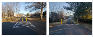
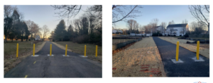
However, my initial joy over these new connections was soon marred by disappointment and dread upon seeing the four photos of dangerous, unnecessary, and closely placed rigid trail bollards on Slides 20 and 21 of the Manassas Public Works annual report.

While intended to prevent both intentional and accidental intrusions by motor vehicles–and occasionally needed to prevent costly damage to fragile infrastructure, such as foot bridges–hard, rigid bollards installed within the traveled way of shared-use paths have been widely recognized for decades as a substantial hazard for people riding bicycles, causing many severe and permanent injuries and even deaths.   An extensive bicyclist critique of trail bollards is posted here.

For that reason, nationally recognized guidance for the design and construction of shared-use paths have long cautioned against installing hard, rigid bollards on shared-use paths.   A variety of simple and cost-effective alternative design treatments—starting with signs prohibiting entry by motor vehicles—are quite effective at preventing motor vehicle intrusions and vastly safer than trail bollards.

Although NOVA Parks’ 45-mile Washington and Old Dominion (W&OD) Trail includes scores of at-grade road crossings, NOVA Parks removed all of its former bollards and fences along that trail more than 20 years ago, in recognition of the significant danger that such obstructions pose to trail users.  NOVA Parks has not seen any need to reinstall trail bollards since.

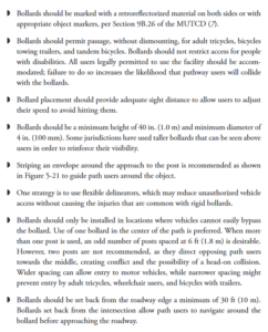
Where the risks and consequences of unwanted motor vehicle entry is significant and demonstrated, trail bollards should be installed only on the centerline of two-way shared-use paths, and flexible bollards should be used if feasible.  If multiple bollards must be used, they should be used in sets of three (never two or four, to reduce head-on collisions) and spaced at least five feet apart to allow safe passage by bicycle trailers.

The Federal Highway Administration has long warned against installing bollards on recreational trails.  The first bullet point states:  “Even “properly” installed bollards constitute a serious and potentially fatal safety hazard to unwary trail users. In addition, no bollard layout that admits bicycles, tricycles, and bicycle trailers can exclude single-track motor vehicles such as motorcycles and mopeds. For these reasons, bollards should never be a default treatment, and should not be used unless there is a documented history of intrusion by unauthorized cars, trucks, or other unauthorized vehicles.”

Similarly, the AASHTO Guide for the Development of Bicycle Facilities (4th Edition, 2012) contains extensive guidance on trail bollards on pages 5-46 and 5-47, including these paragraphs:

Since the above-referenced newly installed trail bollards are a well-recognized defective and unreasonably dangerous property condition for people riding bicycles, scooters, skate boards, and other devices, I ask that these trail bollards be removed immediately from the paths at Kinsley Mill Park, Tudor Lane, Oakenshaw Park, and Bartow Street and that none be installed along the still-unfinished path along the southern perimeter of the Metz Middle School property.

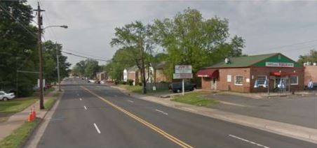
I’m confident the City of Manassas would never install a rigid bollard within a few feet of any vehicular travel lane, although such obstructions would mostly endanger vehicle exteriors, not human bodies.  So, how can it be considered acceptable to expose non-encapsulated people traveling on balanced bicycles (or simply walking) to such dangerous obstructions?

###

2018 Manassas Community Conversations and Comprehensive Plan Update

Content derived from http://manassascity.org/2431/Comprehensive-Plan-Update

Using an 18-month process, the City of Manassas will update its Comprehensive Plan–the City’s key policy document for land use, development, preservation and related economic and social issues.  As part of that update, the City will also develop its first Transportation Master Plan to guide future transportation investments and improve mobility in the City.  This is an exciting time for City residents as the Manassas community envisions its future!

Citizen input in updating the Comprehensive Plan is vital to a more livable Manassas.  Throughout the summer and fall, the City will host a second round of Community Conversations on key topic areas, like land use and transportation.  These conversations began on June 19th with a visioning session on land use.  Additional meetings are scheduled throughout the summer and fall.  City Staff will also be available to meet with neighborhood and community organizations to gather feedback. Please contact 703-257-8223 for more information about hosting a meeting.

Upcoming Meetings

Parks & Recreation Community Conversation
hosted by the Parks & Recreation Committee
Wednesday, July 11th – 7 PM @ Manassas Museum, 9101 Prince William Street

Community Appearance & Environment Community Conversation
hosted by the Manassas Beautification Committee
Thursday, July 19th – 7 PM @ Public Works, 8500 Public Works Drive

Economic Development Community Conversation
hosted by the Manassas Business Council
Thursday, August 2nd – 12 PM @ Centerfuse, 9071 Center Street

Infrastructure Community Conversations
hosted by the Utility Commission
Thursday, August 9th – 7 PM @ Public Works, 8500 Public Works Drive

Culture & Historic Resources Community Conversation
hosted by the Historic Resources Board
Tuesday, September 4th – 7 PM @ Manassas Museum, 9101 Prince William Street

Community Conversation Town Hall
hosted by the Manassas City Council
Monday, September 17th – 7 PM @ Location TBA

Past Meetings

Comprehensive Plan Kickoff & Community Conversation on Land Use
hosted by the Planning Commission
Tuesday, June 19th– 7 PM @ Boys and Girls Club, 9501 Dean Park Ln.

Land Use Community Conversation Meeting Materials

Land Use Community Conversation Presentation

Additional Resources

About the Update

Current Comprehensive Plan

Community Conversations Phase 1

Sign Up for Updates

View coverage of the Community Conversations Kick Off meeting:

community conversations link

Please visit www.manassascity.org/planmanassas for additional information and additional meeting dates.

The City of Manassas is Poised to Revamp Grant Ave with the City’s First Road Diet, Citing Pedestrian Safety Concerns

The City of Manassas is in the planning stages of a redesign of Grant Avenue, a road considered the southern gateway to downtown Manassas. Citing pedestrian safety and safe routes to schools, City staff are considering a road diet from 4 to 3 lanes with improved pedestrian sidewalks and crossings. A public meeting was held on 29 June with additional public engagement in the planning process to come in the future. Implementation of the Grant Ave Streetscape Project will also enable the city to move forward with smart growth re-development on the southern side of the city.

Streetscape Meeting

Manassas Grant Ave Streetscape Meeting

At the public meeting on 29 June, there was considerable staff, consultant, and community support for implementing a four-lane to three-lane road diet to improve walking and bicycling conditions, enhance bus stops, and increase aesthetics without significantly degrading motoring. Mayor Parrish, three current City Council members, and senior City staff were present at the meeting.

Existing Condition Comments

Manassas Grant Ave Streetscape Existing Condition Comments

At the meeting, staff guided interested individuals in using the Streetmix computer program to design alternative cross sections for Grant Ave.  While conventional bike lanes are eminently feasible and should be adequate for many bike riders with a road diet’s traffic-calming influence and a lowered 25 MPH speed limit, it was clear that the current street right of way is constrained, and expanding the sidewalk areas to include planting strips with street trees, urban street lamps, and bus shelters is an important “competing” priority that may preclude adding buffered or separated bicycle lanes.

View near Brent St.

Manassas Grant Ave view near Brent St.

While a simple road diet can often be accomplished using only maintenance funds to repave and re-paint the new lane configuration, expanding the sidewalks and planting strips, undergrounding the currently overhead utilities, and adding bus shelters, urban street lights, street furniture, trees, and other landscaping along Grant Ave will necessitate considerable construction funds.

The Initial planning and design for the project has been funded, but there’s not yet any funding allocated for construction, and thanks to HB 2 and HB 599, which target road capacity expansions, neither the Virginia Commonwealth Transportation Board (CTB) nor the Northern Virginia Transportation Authority (NVTA) are likely to provide any money for a road diet.  If construction will be locally funded, it’s unlikely that the curbs will be moved, so as to greatly reduce construction costs.  At the meeting, Active Prince William advocated for alternatives–including buffered bike lanes–that could fit within the existing roadway.

Example Road Profile

Grant Ave Streetscape Example Road Profile

For more information, visit the City’s project page [http://www.manassascity.org/grantave], where you can sign up for project updates, and view the meeting presentation which provides background information and describes how the meeting was conducted.

Newer posts »