Advancing active mobility in greater Prince William, Virginia

Tag: Highway Project Design

Our Input for the Route 234-Clover Hill Road Bowtie Intersection

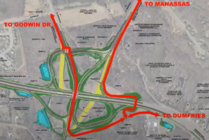
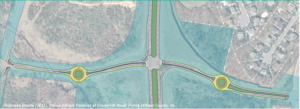
2017 Concept for a Clover Hill Road/Prince William Parkway “Bowtie” Intersection

Recently, the Prince William County Department of Transportation asked for our feedback on their proposed preliminary design for rebuilding the intersection of the Prince William Parkway (Route 234) and Clover Hill Road near Manassas as an “innovative” bowtie intersection, where all direct left turns are eliminated and instead accommodated via two roundabouts on the minor cross street.   Our reply is posted below.   We will track this upcoming project in the coming years as the design is refined for construction.


Thank you for soliciting Active Prince William’s input on how the redesigned intersection of Clover Hill Road at the Prince William Parkway can best serve people walking and bicycling.

Conventional On-Road Bike Lanes Are Appropriate for Clover Hill Road

Clover Hill Road provides an important low-traffic bicycling connection between the City of Manassas (and adjacent residential neighborhoods within the County) and Manassas Regional Airport and points west, including the Broad Run VRE station and the new Route 28 shared-use path that now extends though Bristow all the way to Nokesville.  On the southwest side of Route 234, Clover Hill Road provides critical bicycling access to a network of low-traffic, bicycling-friendly roads within and near Manassas Regional Airport, including Harry J Parrish Blvd. Wakeman Drive, Observation Drive, Piper Lane, Residency Road, Pennsylvania Avenue, Carolina Drive, and Gateway Blvd.

As such, Clover Hill Road is eminently useful for bicycle commuting to employment sites within and near the airport, to the Broad Run VRE station, and to points west in Bristow.  In addition, Clover Hill Road and the low-traffic roads within and around the airport are used extensively for recreational bicycling on evenings and weekends.

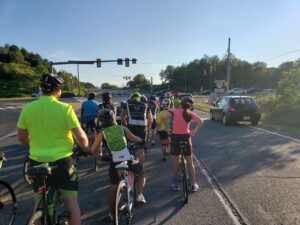
Bicyclists on Bull Run Bicycle’s Tuesday evening shop ride wait to cross Route 234 at Clover Hill Road. To avoid hazardous right-turning traffic on both sides of this intersection, the group waits for a green traffic signal in the left travel lane of Clover Hill Road.

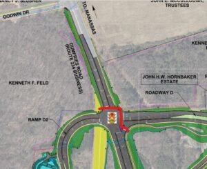
Both City of Manassas roadways that connect to this segment of Clover Hill Road–i.e.. Clover Hill Road from Godwin Drive to Wellington Road and Godwin Drive from Clover Hill Road to Hastings Drive–already have conventional on-road bike lanes.  Thus, in addition to including sidewalks for pedestrians, the entire redesigned segment of Clover Hill Road should include conventional on-road bike lanes in both directions.

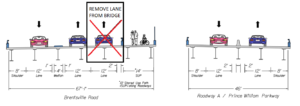
Note that VDOT’s website that describes bowtie intersections includes conventional on-road bike lanes on all four legs of that intersection (see the illustration copied below).

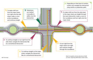
Since, as in the above illustration, the proposed design features dedicated right-turn-only lanes on Clover Hill Road at both approaches to the Prince William Parkway, it would be vital to install the bike lanes at both approaches to the Prince William Parkway between the straight-through travel lane on the left and the right-turn-only lane at the curb.

Within the roundabouts, the bike lanes–if any–should be on the far right and could be buffered or physically separated from roadway traffic.  Alternatively, especially if right-of-way is constrained at the roundabouts, the bike lanes could be discontinued within the roundabouts and bicyclists encouraged to navigate the roundabouts as either a driver centered within the travel lane or (using strategically placed curb ramps for access and egress) as a pedestrian using the sidewalk.

However, upon exiting each roundabout, right-turning motorists should be directed to yield to any bicycle traffic ahead and to carefully merge right across the continued bike lane to enter the emerging right-turn-only lane before reaching either the Parkway (along both southbound and northbound Clover Hill Road) or Godwin Drive (along northbound Clover Hill Road).

Please note that these same conflicts between right-turning motorists and straight-through bicyclists presently exist at the current Clover Hill Road/Route 234 Intersection in the absence of any bike lanes and that appropriate traffic engineering measures, involving pavement markings and signage, can optimize the safety of all road users.

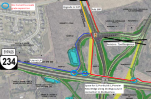
Design This Intersection to Safely Accommodate the Future Shared-Use Path Along Route 234

Although this project won’t construct the long-planned missing shared-use path along Route 234, the design of this intersection should not preclude its future construction and should also ensure that pedestrians and bicyclists using that shared-use path can cross Clover Hill Road safely.  As a designated segment of the National Capital Trail Network, a continuous, high-quality shared-use path along Route 234 should be a priority for Prince William County.

Unobstructed right-of-way should be acquired and preserved as part of this project to accommodate the future Route 234 shared-use path, and the project design should ensure that the route and future design of this path would not be blocked or compromised by noise barriers, above-ground or buried utilities, or roadside signage, traffic signals, or street lighting.  Until the county decides whether this path will be constructed on the northeast or southwest side of Route 234, right-of-way should be reserved for the future shared-use path on both sides.

In addition, the intersection design should ensure that the future Route 234 Trail will have a safe, at-grade crossing of Clover Hill Road, presumably coordinated with the same traffic signal that regulates the Route 234 traffic.

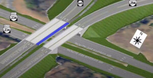
Eliminate High-Speed Right-on-Red Turning Movements from Route 234 onto Clover Hill Road

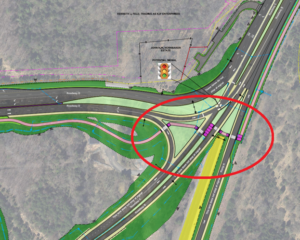
Unlike VDOT’s model bowtie intersection illustrated above, the currently proposed intersection design incorporates two free-flowing, high-speed, right-turning movements, using pork-chop islands, for Route 234 traffic to enter Clover Hill Road.  We believe this currently proposed design feature would seriously endanger both 1) bicyclists and pedestrians crossing Route 234 at Clover Hill Road and 2) the users of the future Route 234 Trail crossing Clover Hill Road.

Vulnerable, non-motorized road and trail users who are crossing either roadway on a green traffic signal should not be endangered by high-speed traffic that is simultaneously turning right-on-red at near-freeway speeds at these pork-chop islands.  While a decision to completely ban all right-turn-on-red movements at this intersection might best be made by expert traffic engineers, we firmly believe that free-flowing right-on-red movements would be dangerous at this intersection and should not be promoted by design features such as pork-chop islands.

Instead, vehicle traffic entering Clover Hill Road from Route 234 should be encouraged to slow to the 25 MPH posted speed and carefully merge into the single travel lane approaching the roundabout, while bicyclists who have just crossed Route 234 on a green signal must merge into the bike lane at the right edge of the roadway.

Again, careful pavement marking and signing would help all road users safely negotiate these conflicts, whereas a design that promotes high-speed right-on-red vehicle traffic would endanger vulnerable road users.

Bicyclists and pedestrians crossing Route 234 at Clover Hill Road on a green traffic signal would primarily be endangered by motorists turning right-on-red from Route 234 at the far side of their crossing.  By contrast, users of the future Route 234 Trail crossing Clover Hill Road on a green traffic signal could encounter both motorists turning right-on-green from Route 234 as well as motorists turning right-on-red from Clover Hill Road.   All such right-turning movements would be safer if the design encourages motorists to slow or stop completely before entering a crosswalk and turning into the path of vulnerable road users.  Partial traffic signal phasing, such as leading pedestrian intervals, could also make these crossings safer.

Clover Hill Road is a local street posted for 25 MPH, and there is no compelling need to promote free-flowing right-turn-on-red vehicle movements onto Clover Hill Road.

The 2019 AADT for all connected local roadways (i.e., Clover Hill Road, Godwin Drive, and Harry J Parrish Blvd) ranges from 2100 to 4700, so Clover Hill Road only needs one travel lane per direction between intersections. The proposed design includes a grassy median along Clover Hill Road, but there’s no compelling need for a grassy median on a road posted for 25 MPH, and that grassy median is about a full-lane wide on the segment approaching Godwin Dr.

Active Prince William also supports the inclusion of a shared-use path along this entire segment of Clover Hill Road; however, such a path would not connect to any existing path along Clover Hill Road, Godwin Drive or Harry J. Parrish Blvd, and it appears that the long-planned path along the Route 234 Bypass won’t be built for the foreseeable future.  Thus, a shared-use path seems less essential, especially on the airport side of Route 234, provided that both sides of Clover Hill Road will have sidewalks and bike lanes.

If spatial or terrain constraints would otherwise preclude the addition of both on-road bike lanes and sidewalks along Clover Hill Road in both directions, consideration should be given to narrowing or eliminating the grassy medians.

Thank you for considering our input.

###

While Better, the Revised Design of the Route 234-Brentsville Road Interchange in Still Badly Flawed

Prince William County DOT’s currently proposed circuitous trail routing through the Interchange, assuming that a direct trail bridge connecting the existing Route 294 and Route 234 Trails is included in this project

Our proposed trail connections through the planned interchange to reach Route 234 Business (red line) and the future trail along the Route 234 Bypass (blue line).  A trail (red line) running along the north side of Route 234 would pass underneath both new roadway overpasses. The three light blue circles show where box culverts could allow the trail to be routed beneath highway ramps.  The areas shown in yellow are existing roadways that are planned to be removed.  This design eliminates all at-grade trail-roadway crossings, except to reach Route 234 Business.  However, by building a shared-use path along the west side of Route 234 Business (connecting to Godwin Dr), trail users would be required to cross only 5-lanes of stopped traffic at just the western leg of the signalized intersection of Bradley Cemetery Way and Route 234 Business, not 12-lanes of stopped traffic plus one lane of free-flowing right-turning traffic at two separate legs of that intersection.

This post follows up on the comments we previously submitted in response to the December 8, 2021 Design Public Hearing for Prince William County DOT’s Route 234-Brentsville Road Interchange Project.

On March 18, 2022, the County released this followup video presentation on the proposed project design.   County DOT staff are willing to at least partly addresses three concerns with the proposed trail connections that were raised at the Design Public Hearing:

1) In response to public comments from Active Prince William and others, the County is now studying the cost feasibility of a new, dedicated trail bridge over Rte 234, just east of the interchange, to directly connect the existing trails along Route 234 and Route 294.   If this trail bridge can be added without the project exceeding it’s $55 million budget, it will be included in this project.   Otherwise, it probably won’t.

2) In response to safety concerns raised by many about the four proposed closely spaced at-grade trail crossings of free-flowing highway ramps near Route 294 and Bradley Cemetery Way in the northeast corner of this project, those hazardous at-grade trail crossings may not be built, at least if the added trail bridge discussed above is actually built.    However, this change would produce a long, circuitous trail route between the western legs (Route 234 Bypass and Route 234 Business) and eastern legs (the existing trails along Routes 234 and 294) of this interchange (shown in the top image above).

3) In response to objections that the design completely omits the long-planned trail along the Route 234 Bypass that should join the existing trails along Route 234 and Route 294,  the design team has identified a future location for this trail along the northwestern edge of the interchange (see the blue line in the second image above).

However, all trail connections to and from Route 234 Business and the long-planned future trail along the Route 234 Bypass (aka Route 234 North) would still require a two-stage at-grade crossing of 12 signalized traffic lanes plus one free-flowing right-turn lane at the rebuilt intersection of Bradley Cemetery Way and Rte 234 Business plus a second at-grade trail crossing of a free-flowing highway ramp at the south side of the interchange (at the on-ramp from Brentsville Road) .  Those remaining design flaws would still create considerable delays and hazards for trail users.

Under Prince William DOT’s revised design for this interchange, this slow and hazardous crossing of 13 traffic lanes at two legs of the signalized intersection of Bradley Cemetery Way and Route 234 Business would remain.  All trail access and egress from either Route 234 Business or the future trail along the Route 234 Bypass would need to use this routing to join either of the existing trails along Route 234 and Route 294 or Brentsville Road.

As a followup proposal, we suggest routing the long-planned trail along the Route 234 Bypass along the north side of Route 234 (per the second image from the top), connecting that trail to both the existing Route 294 Trail to the east and to a new shared-use path along the west side of Route 234 Business (where the existing pavement, depicted in yellow, is planned for removal).   This trail (depicted with a red line in that image) would pass underneath both new roadway overpasses being built to carry Brentsville Road and Route 294 over Route 234 and could also pass underneath three single-lane interchange ramps inside box culverts (see the light blue circles).

Under our proposal, the long-planned trail along the Route 234 Bypass would run along the north side of Route 234 and pass under both planned roadway bridges.


Three short box culverts could be used to route our proposed trail along the north side of the Route 234 Bypass beneath three one-lane interchange ramps.  Only one such box culvert would be needed for the connection to Route 234 Business.

Our proposed design eliminates all at-grade trail-roadway crossings, except to reach Route 234 Business.  However, by building a shared-use path along the west side of Route 234 Business (connecting to Godwin Dr), where only a sidewalk is currently planned, trail users would be required to cross only 5-lanes of stopped traffic at just the western leg of the signalized intersection of Bradley Cemetery Way and Route 234 Business, not 12-lanes of stopped traffic plus one lane of free-flowing right-turning traffic at two separate legs of that intersection.

Our proposal could also lower the cost of this project by eliminating the need to include a 14-foot wide shared-use path on the proposed Brentsville Road bridge.

Active Prince William believes that first-class, safe and direct trail connections for all five legs of this interchange can and should be provided within this project’s existing budget of $55 million.

Active Prince William’s Initial Comments on the Proposed Design of the Route 234-Brentsville Road Interchange

 
PROBLEM:
Forcing bicycle and pedestrian users to cross FOUR separate free-flowing, high-speed vehicle lanes is an unacceptable way to connect two of the major trails in the county.  The section should be removed from the design.  It is too dangerous.  [Added Note: The proposed design forces bicyclists and pedestrians to negotiate a fifth high-speed at-grade road crossing (of the ramp from northbound Brentsville Road to southbound Route 234) to actually link these two major trails.  Furthermore, to access or egress Route 234 Business/Dumfries Rd, bicyclists and pedestrians would be forced to negotiate a sixth high-speed at-grade road crossing plus 12 vehicle lanes at two controlled intersection legs at Bradley Cemetery Way.]


RECOMMENDED SOLUTION:
Add an additional bike/ped bridge crossing of Route 234 south/east of the planned interchange to directly and safely connect the Route 234 Trail and the Prince William Parkway Trail.


HOW TO PAY FOR THIS RECOMMENDED SOLUTION:
1) Remove the proposed bike/ped infrastructure with four at-grade roadway crossings from the Bradley Cemetery Way area:

2) Change the Continuous Green-T Intersection at Brentsville Road and the off-ramp from VA234 Bypass South to a Roundabout, Standard Two-Phase Traffic Light or a Three-Way Stop Sign.  Future traffic volumes do not warrant the expensive infrastructure needed for a Continuous Green-T Intersection.

3)  Remove one northbound lane from the planned Brentsville Road Bridge to create a smaller/cheaper bridge footprint.  Future traffic volumes do not warrant having two northbound vehicle lanes on this bridge.

Design Public Hearing for PWC’s Route 234-Brentsville Road Interchange Project, December 8, 2021 at 6:00 PM

Prince William County’s proposed Route 234-Brentsville Road Interchange includes four treacherous at-grade shared-use path crossings of free-flowing high-speed roadways to link the Prince William Parkway and Route 234 sidepaths.   As an alternative to this dangerous and circuitous trail routing, Active Prince William advocates a simple trail overpass on the east/south side of this interchange to safely and directly link Prince William County’s two major trails.


From the Office of Coles District Supervisor Vesli Vega:

A public hearing on the proposed Brentsville Interchange Project will be held on Wednesday, December 8th at 6pm at the Lake Jackson Volunteer Fire Department, 11310 Coles Drive in Manassas.

The meeting can also be viewed live online at https://www.pwcva.gov/department/transportation/current-road-projects.  The Project team will make a short presentation beginning at 6:30 p.m. and answer questions for the duration of the meeting.

The purpose of the public hearing is to receive public comments on the design of the Route 234 Brentsville Road Interchange Project and associated Limited Access Control Changes in the Coles Magisterial District.  This Project will involve a change and break in Limited Access Control.

Preview the Project information and Design Public Hearing plans including the environmental documentation on the Prince William County Department of Transportation website at https://www.pwcva.gov/department/transportation/current-road-projects.  [Note: The five linked documents related to the current design are listed at the bottom, with links depicted in green.  The blue links are for the obsolete March 2020 design].

The deadline to submit comments is December 18, 2021.  The public may provide written or verbal comments at the Design Public Hearings, mail them to Ms. Mary Ankers, P.E., Project Manager, at the Prince William County Department of Transportation, 5 County Complex, Suite 290, Prince William, VA 22192, or email them to [email protected].   Please reference “Route 234 Brentsville Road Interchange Project PH Comments” in the subject heading.

Please find the Project Schedule Below:

Virtual Public Meeting on Van Buren Road North Extension Environmental Study, Thursday, July 22, at 7:00 PM


From a Prince William County news release:

The Prince William County Department of Transportation invites you to attend a Virtual Information Meeting and learn more about the Van Buren Road Alignment and Environmental Study. This project will identify the project alignment which consists of extending Van Buren Road from Route 234 to the existing connection at Cardinal Drive, and the in-progress Environmental Study for this improvement.

The on-going environmental study is budgeted at $1,300,000. Funding for the final design and construction of the Van Buren Road North Extension has not yet been identified.

The project will provide relief to existing and projected traffic congestion as an alternate north-south route along the I-95 and Route 1 corridors. In alleviating congestion in this heavily travelled corridor, safety is improved, and mobility is enhanced to the nearby community schools and facilities.

The purpose of this virtual information meeting is to give the public an opportunity to review the project exhibits, review a tentative project schedule, and provide feedback to the County to assist in finalizing the environmental study. Comments can be submitted either online at the below website or by mail. The public is also invited to ask questions at the conclusion of the presentation utilizing the Question and Answer (Q&A) function. A comment sheet will be available at the same website. Please submit your comments by close of business on August 5, 2021.

A recording of this meeting and the meeting presentation will be posted on the Prince William County Department of Transportation webpage.

Meeting Registration Information

  •  Dial In: +1-415-655-0001  Access code: 172 658 5243

Comments Due Thursday, August 5th at 5:00 PM.

 To submit comments, questions, or feedback, please contact PWCDOT:


Brochure for the June 22, 2021 public information meeting  The proposed design includes four 12-foot wide travel lanes, a 16-foot wide grassy median,  a 10-foot wide shared-use path along one side of the road, and a 5-foot wide sidewalk along the other side of the road.

Comment sheet for the June 22, 2021 public information meeting