Advancing active mobility in greater Prince William, Virginia

Tag: planning

The City of Manassas is Poised to Revamp Grant Ave with the City’s First Road Diet, Citing Pedestrian Safety Concerns

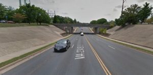
The City of Manassas is in the planning stages of a redesign of Grant Avenue, a road considered the southern gateway to downtown Manassas. Citing pedestrian safety and safe routes to schools, City staff are considering a road diet from 4 to 3 lanes with improved pedestrian sidewalks and crossings. A public meeting was held on 29 June with additional public engagement in the planning process to come in the future. Implementation of the Grant Ave Streetscape Project will also enable the city to move forward with smart growth re-development on the southern side of the city.

Streetscape Meeting

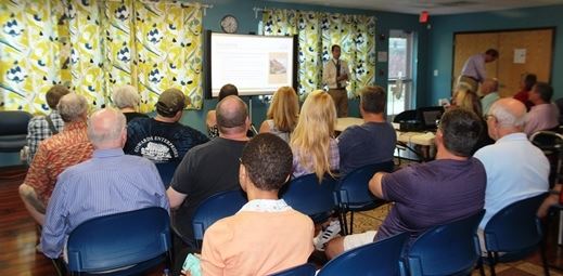
Manassas Grant Ave Streetscape Meeting

At the public meeting on 29 June, there was considerable staff, consultant, and community support for implementing a four-lane to three-lane road diet to improve walking and bicycling conditions, enhance bus stops, and increase aesthetics without significantly degrading motoring. Mayor Parrish, three current City Council members, and senior City staff were present at the meeting.

Existing Condition Comments

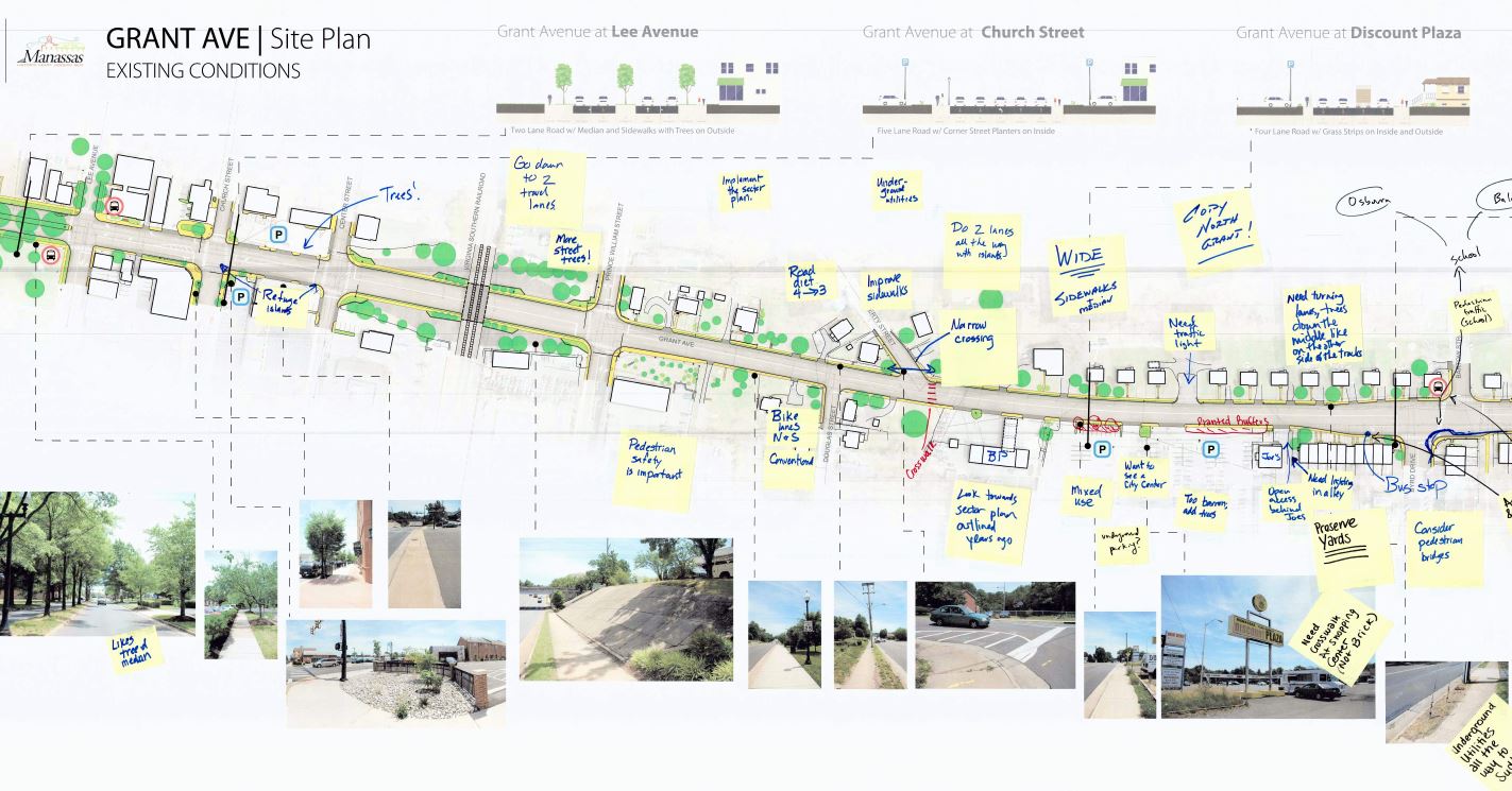
Manassas Grant Ave Streetscape Existing Condition Comments

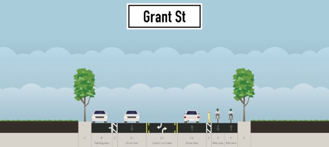
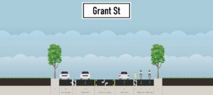
At the meeting, staff guided interested individuals in using the Streetmix computer program to design alternative cross sections for Grant Ave.  While conventional bike lanes are eminently feasible and should be adequate for many bike riders with a road diet’s traffic-calming influence and a lowered 25 MPH speed limit, it was clear that the current street right of way is constrained, and expanding the sidewalk areas to include planting strips with street trees, urban street lamps, and bus shelters is an important “competing” priority that may preclude adding buffered or separated bicycle lanes.

View near Brent St.

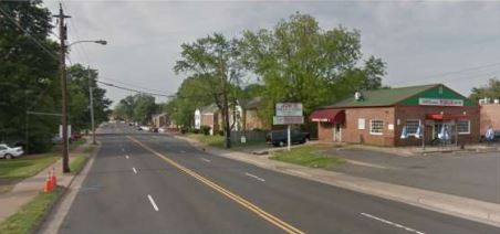
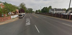
Manassas Grant Ave view near Brent St.

While a simple road diet can often be accomplished using only maintenance funds to repave and re-paint the new lane configuration, expanding the sidewalks and planting strips, undergrounding the currently overhead utilities, and adding bus shelters, urban street lights, street furniture, trees, and other landscaping along Grant Ave will necessitate considerable construction funds.

The Initial planning and design for the project has been funded, but there’s not yet any funding allocated for construction, and thanks to HB 2 and HB 599, which target road capacity expansions, neither the Virginia Commonwealth Transportation Board (CTB) nor the Northern Virginia Transportation Authority (NVTA) are likely to provide any money for a road diet.  If construction will be locally funded, it’s unlikely that the curbs will be moved, so as to greatly reduce construction costs.  At the meeting, Active Prince William advocated for alternatives–including buffered bike lanes–that could fit within the existing roadway.

Example Road Profile

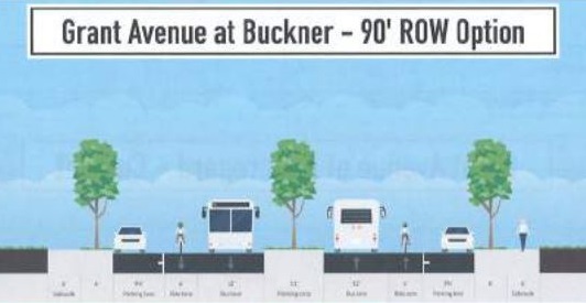
Grant Ave Streetscape Example Road Profile

For more information, visit the City’s project page [http://www.manassascity.org/grantave], where you can sign up for project updates, and view the meeting presentation which provides background information and describes how the meeting was conducted.

Dale City Revitalization Project Public Open House

Prince William County is holding a public open house for a presentation on the Dale City Revitalization Project at the Hylton Memorial Chapel, 14640 Potomac Mills Rd, Woodbridge, VA on Monday 18 July, 2016 from 6:00 – 8:00 PM. The presentation will focus on suggested improvements for revitalization of the Dale Blvd-Minnieville Rd area in Dale City that have been developed this year, with community input.

Dale City Revitalization Public Meeting Announcement

Dale City Revitalization Public Meeting Announcement (click to open)

The Dale City Revitalization Project is a continuation of the planning efforts initiated by the Prince William County Planning Office beginning with last year’s American Institute of Architects (AIA) Sustainable Design Assessment Team (SDAT) report (link to report here). Issues identified in the original SDAT report include developing a sense of place for Dale City, addressing transportation deficiencies such as a lack of sidewalks, bike paths and connections to neighborhoods, revitalizing run-down commercial properties, and adding genuine community spaces. The SDAT report suggested a focus on two areas, the Dale Blvd-Maple Dale intersection, and what they termed, The Streets at Minnieville and Dale.

Streets at Minniville and Dale Map

Streets at Minniville and Dale Map

The County successfully submitted a proposal for a Metro Washington Council of Governments (MWCOG) grant for a Transportation and Land Use Connection (TLC) Project that has funded further planning work on “The Streets of Minnieville and Dale” design concept. The open house presentation will include details developed from this new planning project that were shaped through a process of community input.

Dale City - Dale Blvd/Minnieville Revitalization Map

Dale City – Dale Blvd/Minnieville Revitalization Map

The Prince William County Planning Office contact for the project is Ryan Foster, Community Development Manager. He can be reached by phone at 703-792-7359 or [email protected]

City of Manassas Solicits Ideas to Improve Grant Ave

The City of Manassas is soliciting ideas for how to improve Grant Avenue at a public meeting on Wednesday 29 June 2016 at 7PM in the Georgetown South Community Center, 9444 Taney Rd, Manassas, VA. Active Prince William encourages residents to attend the meeting and provide input on ways to help make Grant Avenue a safer place to bike and walk.

GrantAve Streetview at railroad underpass

GrantAve Streetview at railroad underpass

The public meeting on Wednesday is the beginning of the planning process for the Grant Ave corridor from Lee Ave to Wellington Rd. The Manassas spokeswoman who announced the project stated that the intent is to consider potential improvements to the existing public right-of-way without acquiring additional private property. The City mentioned potential pedestrian improvements as an option, but there was no mention of bicycling improvements. This is an opportunity to suggest that Grant Ave should be a safer place to ride bikes and walk.

Grant Ave Road Profile Proposal

Grant Ave Road Profile Proposal – courtesy of @FixRoute28 (on Twitter)

In its current state, this section of Grant Ave is unfriendly to bicyclists. Active Prince William’s Bicycle Comfort Level Map (http://ow.ly/c24d100cBbG) shows this stretch as “Low Comfort” due to multiple lanes of traffic, high traffic volumes, and no accommodations for bicycles along the route.

Grant Ave StreetView

Grant Avenue StreetView at Taney Rd

See additional details from the announcement here.

Bi-County Parkway Gone from County Plan; Takes Safe I-66 Bicycle Crossing With It

On March 15th, the Prince William County Board of County Supervisors voted to remove the Bi-County Parkway from the County’s Comprehensive Plan. Unfortunately, along with it goes one of only a few planned shared-use trail crossing of Interstate 66 (I-66). Options to replace the trail crossing in the comprehensive plan may soon be considered by the County Planning Office.

I66 - Route 234 Interchange Overview

Active Prince William supported Supervisors’ vote, as the Bi-County Parkway would have negatively impacted the protected Rural Crescent and increased truck traffic through Prince William County, while primarily benefiting Loudoun County and the Dulles Airport Authority (more background on the Bi-County Parkway). But the now-defunct Parkway did include one key benefit for Prince William residents: the plan called for a shared-use trail along its entire length, opening up a significant area for recreation to many Western Prince William County residents, and providing a key crossing of I-66, which is a significant barrier to bicylists, hikers, and walkers in the Manassas National Battlefield Park and the surrounding area. Now plans need to be updated to replace the shared-use path crossing of I-66 that was lost with the removal of the Bi-County Parkway.

Options to replace the Bi-County shared use path crossing of I-66 may soon be considered by the County’s Planning Office as part of a technical update of the County’s trails and non-motorized transportation portions of the Comprehensive Plan, or during the Transportation Chapter update that will begin in the next year. The Prince William County Trails and Blueways Council (TBC) has discussed adding Groveton Road to the Comprehensive Plan as an I-66 crossing along with the addition of proposed bicycling improvements for Pageland Lane, a partly unpaved road that parallels I-66 West from Groveton then turns North where the Bi-County Parkway would have been built (see the map below, key: Bi-County Parkway in Red, Groveton Road in Green, and Pageland Lane in Blue).

The only existing safe crossing of I-66 along the approximately 10 mile stretch from the Fairfax County line to Route 15 is located at University Blvd (see map below). Other planned crossings are currently unsafe for people walking or biking, and include:

  • Sudley Rd (Rt 234 Business)
  • Catharpin Rd (under construction)
  • Old Carolina Rd (bridge updated)
  • Rt 15 (under construction)

VDOT has suggested 2 additional bicycle/pedestrian I-66 crossings as part of its future I-66 Outside the Beltway expansion project, under the I-66 overpass at Bull Run and at Groveton Rd. To see the full VDOT I-66 Trail plan, click here. Both of these VDOT proposed trail crossings have been discussed by the TBC, but are not currently in the PWC Comprehensive Plan.

NOTE: Even though PWC is removing the Bi-County Parkway from its Comprehensive Plan, VDOT and others still have plans for the Bi-County Parkway. So, it isn’t necessarily “dead”… yet.