Prince William County (PWC) needs a Department of Mobility, not a Department of Highway Paving. Since the Shirley Highway reached the Occoquan River in 1949, we have paved and paved, at great expense to the environment and taxpayers. Has traffic congestion been eliminated? The answer to this is ‘no’. Expanding highways is not the answer to creating livable communities with sustainable transportation.
Under the last Board of County Supervisors, the scheme was to keep building new roads and widening old roads. Everyone knew it would not “fix” the highways, but land speculators could get rezonings for building new subdivisions if the county would plan to pave more roads. Expanding roads will not solve congestion; that is a lesson learned from several decades of previous road projects in the region and across the country. However, if the county’s land use planning remains isolated from transportation planning, we will just keep repeating the old mistake. A citizen-led Multi-Modal Transportation Advisory Commission, similar to those in Fairfax and Arlington Counties and the City of Alexandria, could increase transparency and citizen involvement in determining how PWC will grow and its residents, workers, and visitors will travel.
So, what is Plan B, if “build roads, build new houses, create new congestion, build roads, build new houses…” does not work? The County’s Strategic Plan is clear – build live-work-play communities that locate housing together with stores and offices, so people can walk, and bike, more rather than drive everywhere for daily living. Invest in increasing the number of jobs within Prince William, rather than fund more roads that incentivize long commutes. We need smart growth planning.
The twenty-four jurisdictions in the Metropolitan Washington Council of Governments agreed on a clear solution on September 11, 2019. PWC joined in setting regional housing targets, with new development concentrated in “Activity Centers.” Each will offer high-capacity public transportation, but walkability within the community will be key. PWC’s six Activity Centers were designated in 2013, based on assumptions about expansion of Virginia Railway Express. Those assumptions turned out to be incorrect. Developing the 2040 PWC Comprehensive Plan creates a great opportunity to re-assess where high-capacity transit really will be provided, vs. drawn as a line on a map and then ignored.
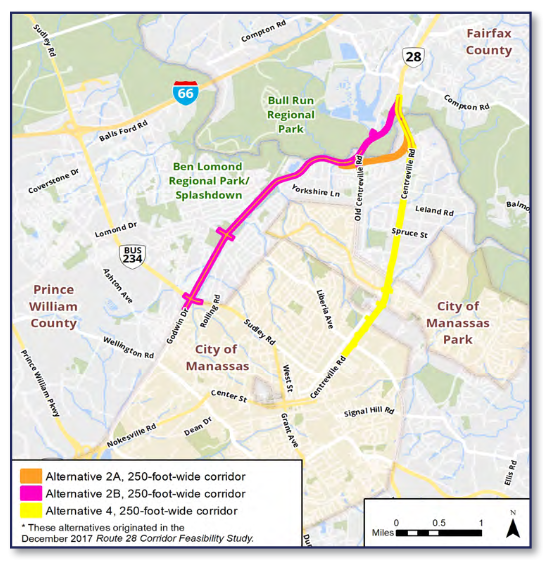
Sadly, on August 4 the supervisors are considering a proposal that would repeat the mistakes of the past. They could approve Alignment 2B of the Route 28 Bypass/Godwin Drive Extension, to build a new commuter highway through the flood-prone Flat Branch stream valley. At least fifty-four homes would be destroyed, and many more would be degraded by increased traffic noise and air pollution.
A community with affordable housing, including a trailer park, would be disrupted so commuters from Fauquier and other counties can temporarily drive a bit faster through PWC. Over six acres of wetlands would be filled in, impacting the natural environment and resilience to climate change. A noise wall would be constructed from Sudley Road to Bull Run, blocking all potential bike/pedestrian access across the highway barrier except at a Lomond Drive intersection.
The traffic analysis report (check the tables on pp. 23-24, and p. 40 for Godwin Dr and for Rte 28 in Fairfax County) indicates that the Alternative 2B commuter Bypass road would create clogged, “failing” intersections on existing Godwin Drive, at all four new Godwin Dr Extension intersections, and along Centreville Rd in Fairfax County (between the north end of the Bypass and I-66). If this Bypass is approved, a future “Fix Godwin Drive” campaign will require even more funding – hundreds of millions for more highway paving. New flyover ramps might have to be added to the interchange of Route 28 and Prince William Parkway/Route 234 Bypass, and Godwin Dr between Nokesville Road and Sudley Road would need widening and intersection improvements . This is not a smart growth approach.
There are better alternatives (including these recent VDOT STARS [Strategic, Targeted, Affordable Roadway Solutions] Study recommendations for Centreville Rd in Yorkshire) but the county’s current Department of Highway Paving will be promoting Alignment 2B on August 4. To stop repeating mistakes and to start applying lessons already learned, the new supervisors need to vote no on Alternative 2B and pursue new innovative solutions.
Residents of Prince William County need a government that uses smart growth principles to guide future land use and transportation decisions. Prince William County residents want livable communities that are great places to work, live, play, and raise a family. Prince William County residents want a sustainable environment that provides a resilient approach to the effects of climate change.
Please call, or email, BOCS Chair Ann Wheeler and your magisterial district supervisor, asking them to vote NO, on August 4, on the proposed Route 28 Bypass/Godwin Drive Extension (Alternative 2B), to pursue innovative smart growth solutions to our mobility issues, and to create a citizen-led Multi-Modal Transportation Advisory Commission that would provide the public and supervisors with thoughtful information and ideas regarding land use and transportation planning decisions.
Email the BOCS with this easy Sierra Club action alert page
More information about the proposed Route 28 Bypass

