Active Prince William

Advancing active mobility in greater Prince William, Virginia

Page 12 of 23

PW County to Host Route 28 Bypass Project Virtual Public Meeting, Thursday, Feb. 18, at 7 PM

Press Release, February 3, 2021
Department of Transportation, 703-792-6273, [email protected]

The Prince William Board of County Supervisors and County transportation staff invite you to attend a virtual information session regarding the Route 28 Bypass project on Thursday, Feb. 18, 2021, at 7:00 p.m. This approximately $300 million infrastructure project, one of the largest in the history of Prince William County, will reduce traffic congestion, improve travel reliability and address other transportation challenges in the area.

The meeting will inform residents about the project’s background, its current status and aspects of the Route 28 Bypass that most directly impact Prince William County residents. While there are no major updates on the project at this time, the session will provide a baseline of information about the Route 28 Bypass while also sharing planned communication activities that will help citizens remain informed and involved as the project moves forward. The latest information about the project is available on Route28Bypass.com.

The Prince William County Department of Transportation (PWC DOT) will continue to host information sessions on the Route 28 Bypass project and address topics specific to Prince William County as the project progresses.

The public is invited to ask questions and provide feedback during the presentation. You may also submit questions or comments before using any of the mechanisms below.

Meeting Registration Information

  • Register to attend the Route 28 Bypass Virtual Meeting:

https://theclearing.zoom.us/webinar/register/WN_P47suUPqQ0O0x1ZBK8KVlA

  • Dial In: +1-301 715 8592 | Webinar ID: 920 6806 7097 | Passcode: 397360

Please submit questions/comments about the Route 28 Bypass using one of the methods below. Submissions received before Feb. 18 at 5 pm may be addressed during the meeting. All questions will be responded to in a timely manner via email or route28Bypass.com.

Have thoughts on how to enhance communication efforts going forward? Please submit any feedback, comments, questions or concerns to PWCDOT:

City of Manassas Installs Dangerous and Unnecessary Trail Bollards

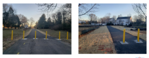
March 15, 2021 Update:  We have  been informed by the City’s Director of Public Works that many of the bollards shown below have been removed.  The City is now installing a single rigid bollard on the trail centerline, with additional bollards placed six feet apart at some locations.  In addition, reflective tape will be installed near the top and the bottom of each bollard.  While these changes significantly reduce the severity of the trail-bollard hazard, the users of these paths will still remain at some risk for serious and permanently debilitating and even fatal injuries from crashing into the remaining bollards.  We urge all public agencies to heed the AASHTO guidance and FHWA recommendation (both cited below) to end the routine use of even single rigid bollards as its default design treatment to discourage motor vehicle incursions on shared-use paths.

July 2023 Update:  The City of Manassas has finally replaced the former rigid black steel bollards at both entrances to its Winters Branch Trail with white plastic flexible posts with silver reflective tape!   Thank you!!!
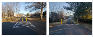
Active Prince William board member Allen Muchnick, a City of Manassas resident, sent the following notice to multiple City of Manassas officials on February 7, 2021:


I was pleased to see the lead article in the January 2021 issue of City Connection newsletter, featuring several newly built asphalt shared-use paths around Manassas.  I commend City staff for working inter-departmentally to quickly fund, design, and build these valuable neighborhood connections.

However, my initial joy over these new connections was soon marred by disappointment and dread upon seeing the four photos of dangerous, unnecessary, and closely placed rigid trail bollards on Slides 20 and 21 of the Manassas Public Works annual report.

While intended to prevent both intentional and accidental intrusions by motor vehicles–and occasionally needed to prevent costly damage to fragile infrastructure, such as foot bridges–hard, rigid bollards installed within the traveled way of shared-use paths have been widely recognized for decades as a substantial hazard for people riding bicycles, causing many severe and permanent injuries and even deaths.   An extensive bicyclist critique of trail bollards is posted here.

For that reason, nationally recognized guidance for the design and construction of shared-use paths have long cautioned against installing hard, rigid bollards on shared-use paths.   A variety of simple and cost-effective alternative design treatments—starting with signs prohibiting entry by motor vehicles—are quite effective at preventing motor vehicle intrusions and vastly safer than trail bollards.

Although NOVA Parks’ 45-mile Washington and Old Dominion (W&OD) Trail includes scores of at-grade road crossings, NOVA Parks removed all of its former bollards and fences along that trail more than 20 years ago, in recognition of the significant danger that such obstructions pose to trail users.  NOVA Parks has not seen any need to reinstall trail bollards since.

Where the risks and consequences of unwanted motor vehicle entry is significant and demonstrated, trail bollards should be installed only on the centerline of two-way shared-use paths, and flexible bollards should be used if feasible.  If multiple bollards must be used, they should be used in sets of three (never two or four, to reduce head-on collisions) and spaced at least five feet apart to allow safe passage by bicycle trailers.

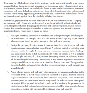
The Federal Highway Administration has long warned against installing bollards on recreational trails.  The first bullet point states:  “Even “properly” installed bollards constitute a serious and potentially fatal safety hazard to unwary trail users. In addition, no bollard layout that admits bicycles, tricycles, and bicycle trailers can exclude single-track motor vehicles such as motorcycles and mopeds. For these reasons, bollards should never be a default treatment, and should not be used unless there is a documented history of intrusion by unauthorized cars, trucks, or other unauthorized vehicles.”
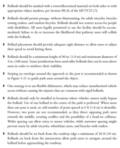
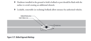
Similarly, the AASHTO Guide for the Development of Bicycle Facilities (4th Edition, 2012) contains extensive guidance on trail bollards on pages 5-46 and 5-47, including these paragraphs:

Since the above-referenced newly installed trail bollards are a well-recognized defective and unreasonably dangerous property condition for people riding bicycles, scooters, skate boards, and other devices, I ask that these trail bollards be removed immediately from the paths at Kinsley Mill Park, Tudor Lane, Oakenshaw Park, and Bartow Street and that none be installed along the still-unfinished path along the southern perimeter of the Metz Middle School property.

I’m confident the City of Manassas would never install a rigid bollard within a few feet of any vehicular travel lane, although such obstructions would mostly endanger vehicle exteriors, not human bodies.  So, how can it be considered acceptable to expose non-encapsulated people traveling on balanced bicycles (or simply walking) to such dangerous obstructions?

###

Advocacy for Bicycle-Related Legislation in the 2021 Virginia General Assembly

Active Prince William board member Allen Muchnick delivered the following personal statement to the Prince William Delegation to the Virginia General Assembly on January 9, 2021.   Some of the comments below have not been officially endorsed by either Active Prince William or the Virginia Bicycling Federation.


Statement to the Prince William Delegation to the Virginia General Assembly January 9, 2021, by Allen Muchnick, Manassas Resident

I’m Allen Muchnick, a City of Manassas resident. I’ve been a board member of the Virginia Bicycling Federation since 1994 and co-founded Active Prince William five years ago.

Both organizations seek safer and more pleasant walking and bicycling and improved justice for pedestrians and bicyclists injured by negligent motorists.

Thank you for passing a wide range of long-delayed progressive legislation in 2020.  We sincerely appreciate the just-implemented ban on using handheld electronic communication devices while driving a motor vehicle, requiring motorists to stop—not merely yield—to persons in crosswalks, establishing a traffic infraction for motorists who negligently injure a pedestrian or bicyclist, and authorizing automated speed cameras at schools and highway work zones.

Legislative changes that we support for the 2021 session include 1) expanding the authorization for automated speed cameras to include residential and business districts, 2) allowing localities to impose urban speed limits below 25 MPH in residential and business districts, and 3) lessening contributory negligence limitations for pedestrians and bicyclists injured in traffic crashes.

We also seek three changes to Virginia’s bicycling laws to increase the safety, comfort, and ease of bicycling.   The bicyclist safety stop would allow bicyclists to treat stop signs as yield signs as long as they yield to all closely approaching cross-traffic.   Stop signs are often installed in lieu of yield signs due to the danger of rolling stops by motorists and as a neighborhood traffic-calming measure. Because bicyclists are generally slower and not inside a vehicle, they can more readily observe and yield to cross-traffic without fully stopping. When bicyclists fully stop their balance is unstable, their effort is greater, and they take longer to clear intersections.  Thus, bicycling injuries have been found to decrease after states have implemented the bicyclist safety stop.

Two related changes would allow bicyclists to ride two abreast at all times and prohibit motorists from passing bicyclists within the same travel lane.  Motorists rear-ending or side-swiping bicyclists is a major cause (ca. 40%) of bicycling fatalities.  Bicyclists riding two-abreast are much more visible to following motorists.  Requiring motorists to execute a full lane change before passing a bicyclist is more understandable to drivers and much easier for police to enforce.

Please ensure that state-funded Potomac River crossing expansions at the American Legion Bridge and at the Long Bridge include substantial bicycle and pedestrian elements, that standalone bicycling and walking improvements are fully eligible for all relevant state and regional transportation funding programs, and that the ban on Sunday hunting on public lands is preserved.  

Thank you for your service and best wishes for a productive legislative session.

###

The Route 28 Manassas Bypass Is Not the Lowest Cost Or the Least Environmentally Damaging Practicable Alternative (LEDPA) for the Route 28 Corridor

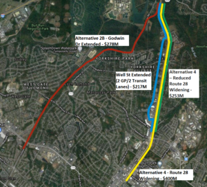
The Alignments of the Four Route 28 Corridor Expansion Alternatives Compared Below

Active Prince William board member Mark Scheufler sent the following comparison of Route 28 corridor alternatives to the Prince William Board of County Supervisors on November 30, 2020.


Dear Prince William Board of County Supervisors:

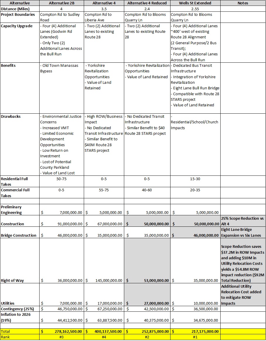
In advance of the December 7th  virtual public meeting on Route 28, it is timely to correct misinformation about the alternatives to Alignment 2B. The costs of Alternative 4 (Widening Route 28) were overstated by calculating the impacts/costs of widening Route 28 between Blooms Quarry Lane and Liberia Ave that is already six lanes.

Realistic cost estimates are needed not only by the supervisors in Prince William and Fairfax counties, but also by the US Army Corps of Engineers and the Virginia Department of Environmental Quality.  Those two agencies may determine that cost differences between Alignment 2B and other alternatives are not sufficient to justify the greater environmental damage.

As the Meeting Minutes at the January 16, 2020 Project Update and Alternatives Development Technical Memo Review  state (on pages 2 and 3):

“Stuart ended with a presentation of the cost summary for the alternatives, which showed that Alternative 4 would be almost $100 million more than Alternatives 2A and 2B. MacKenzie indicated that cost would not be a factor that the Department of Environmental Quality (DEQ) would consider in their evaluation. Rick responded that he understood, but emphasized the need to consider purpose and need in the comparison of the alternatives.

Subsequent to the meeting, Hannah Schul, DEQ, clarified that DEQ makes permitting decisions based on the Least Environmentally Damaging Practicable Alternative (LEDPA). Per the Clean Water Act, a permit cannot be issued if a practicable alternative exists that would have less adverse impacts on the aquatic ecosystem. The LEDPA does take cost into consideration, but an alternative would only be potentially eliminated if costs are clearly exorbitant compared to similar alternatives.”

The analysis summarized in the table below [the complete ROW analysis is here] shows the cost of alternatives along or near existing Route 28 are not exorbitant compared to Alternative 2B.   Alternative 4 includes $37M in ROW impacts along a 1.1-mile section of Route 28 that is already six lanes and should require minimal improvement and no ROW impacts (Blooms Quarry Lane to Liberia Ave).  An additional $54M* in Alternative 4 ROW impacts could be mitigated by increasing the Utility Relocation Costs ($10M).  These modifications would bring the Alternative 4 cost estimate below Alternative 2B.  But implementing the Route 28 STARS recommendation and the Well St Extended recommendation  is the best alternative for the Route 28 corridor to meet transit, revitalization, and climate goals and is the cheapest alternative.  The Well St Extended recommendation was not included in the original set of alternatives because transit, revitalization and climate were not considered part of the project purpose and need.

A Comparison of Four Route 28 Corridor Alternatives (click on the image above to enlarge for reading)

Alternative 2B is not the Least Environmentally Damaging Practicable Alternative (LEDPA) and may not receive permits to move forward.  Creating a regional park along this alignment is the best use of the land in the flood plan.

*8300 CENTREVILLE RD, 8130 OAK ST, 7901 CENTREVILLE RD

If you need any clarification, please let me know.

Thanks,

Mark Scheufler

PWC Resident

« Older posts Newer posts »