Active Prince William

Advancing active mobility in greater Prince William, Virginia

Page 13 of 23

Route 28 Bypass Project Virtual Public Meeting, Monday, Dec. 7, @ 7 PM

Prince William County

PRESS RELEASE

November 25, 2020

Office of Communications
[email protected]
703.792.6606 (office)


Prince William County to Host Route 28 Bypass Project Virtual Meeting Focused on the Fairfax County Connection and Tie-in on Monday, Dec.7

Prince William County, in conjunction with the Fairfax County Department of Transportation, invites you to attend a virtual informational session regarding the Route 28 Bypass project on Dec. 7, 2020, at 7:00 p.m. This approximately $300 million infrastructure project, one of the largest in the history of Prince William County, will reduce traffic congestion, improve travel reliability and address other transportation challenges in the area.

The meeting will inform residents of both counties about the project background, efforts to date, and the current status, focusing on proposed concepts for the Route 28 Bypass connection and tie-in point to the existing Route 28 in Fairfax County.

The Prince William County Department of Transportation (PWCDOT) will host information sessions on the broader Route 28 Bypass project and address topics specific to Prince William County in the near future.

The public is invited to ask questions at the conclusion of the presentation and to provide feedback.

The project team will record the meeting and presentation and post them on the project webpage.

Meeting Registration Information

  • Register to attend the Route 28 Virtual Meeting.
  • Dial In: +1-415-655-0001 | Access code: 180 932 8746

Comments Due Monday, Dec. 7 at 5 p.m.

To submit comments, questions or feedback, please contact PWCDOT:

Department of Transportation
Prince William County
5 County Complex Court
Prince William, VA 22192

  • By phone: 703-792-6273

###

Active Prince William Comments on Regional Climate Action Goal

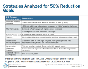
The above slide, from a presentation to the National Capital  Region Transportation Planning Board (TPB) set for October 21, 2020, lists potential strategies to half the D.C. Region’s greenhouse gas (GHG) emissions from 2005 levels over the next ten years. The next step will be to draft and adopt a 2030 GHG Emissions Action Plan.

***

On October 16, 2020, Active Prince William Chair, Rick Holt, sent the following statement to Prince William County’s representatives on the National Capital Region Transportation Planning Board (TPB)–Prince William Board of County Supervisors Chairman Ann Wheeler and Neabsco District Supervisor Victor Angry.   The TPB is scheduled to adopt an ambitious interim 10-year goal to address climate change, by reducing the D.C. region’s emissions of greenhouse gases 50% from their baseline, 2005 level by the year 2030.

***

On October 14, the Metropolitan Washington Council of Governments (COG) Board of Directors pledged to lower our region’s greenhouse gas emissions to 50% below their 2005 baseline level by 2030, as an interim target towards the 2050 goal of an 80% reduction.  We appreciate the COG Board focusing on environmental and climate change issues that affect the quality of life of residents of the Metro D.C. area.

A key step in achieving that goal is to reduce Vehicle Miles Traveled (VMT).  The regional housing targets adopted by the COG Board on September 11, 2019 provide a clear path to minimizing VMT–build 75% of new dwelling units in Activity Centers, within walking distance of high capacity transit nodes.

Prince William County has six designated Regional Activity Centers, based on existing and proposed Virginia Railway Express stations. The Board of County Supervisors may wish to add two more–at Dumfries/Triangle and Yorkshire–if their upcoming Small Area Plans include the creation of a Bus Rapid Transit system comparable to the Pulse in Richmond.

We look forward to you–our representatives on the Transportation Planning Board—actively engaging the other supervisors in how Prince William can meet the interim target in 2030 to reduce greenhouse gas emissions.  In addition to increasing the energy efficiency of buildings and adding solar panels wherever cost-effective, we will need to integrate our land use and transportation planning with our climate change goals in the revised Strategic Plan and 2040 Comprehensive Plan.  On a smaller scale, we ask that you ensure, in the public hearings for proposed Comprehensive Plan Amendments and rezonings, that staff reports identify the impact on Vehicle Miles Traveled, so climate change can be factored into your decisions.

We think you might also find the recent report on carbon emissions, Driving Down Emissions, published this week by Transportation for America to be of interest.   To highlight a passage from the executive summary:  Simply put, we’ll never achieve ambitious climate targets or create more livable and equitable communities if we don’t find ways to allow people to get around outside of a car.  We look forward to working with you and the other members of the Prince William Board of County Supervisors in support of creating livable communities with sustainable transportation options.

###

Environmental Coalition Protests Route 28 Bypass Agreement

Active Prince William, Prince William Conservation Alliance, Southern Environmental Law Center, Sierra Club – Virginia Chapter, Coalition for Smarter Growth, Piedmont Environmental Council, Joint Land Use Committee of the Sully District Council of Citizens Associations and West Fairfax County Citizens Association

PRESS RELEASE

For immediate release:
October 8, 2020 

Contact:
Rick Holt, Active Prince Williiam
Charlie Grymes, Prince William Conservation Alliance
Stewart Schwartz, Coalition for Smarter Growth
John (Jay) W. Johnston, for Joint Land Use Committee

Groups call on Northern Virginia Transportation Authority to defer action on Route 28 project

Calls Route 28 process extremely flawed 

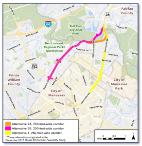
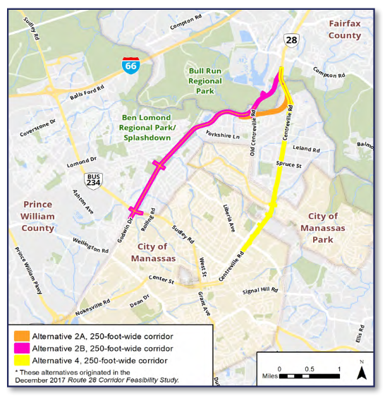
The Northern Virginia Transportation Authority (NVTA) is scheduled to approve a project agreement that will advance Alignment 2B for a Route 28 Bypass at their meeting on October 8. “Our coalition of conservation, smart growth, and transportation reform groups is calling on the NVTA to delay action because of the negative environmental, regional travel, and community impacts of the proposed Alignment 2B and because of significant procedural failings that must be addressed,” said Stewart Schwartz, Executive Director of the Coalition for Smarter Growth.

Rick Holt, Chair of Active Prince William noted that “State law, Section 15.2-2232, requires that new roads be consistent with local comprehensive plans, and that local planning commissions make a finding to that effect. However, Alignment 2B of Route 28, which the Prince William Board of Supervisors approved in a controversial 5 to 3 vote, is not in the Comprehensive Plan for either Fairfax County or Prince William County and has not been reviewed and approved by their planning commissions.”

“The entire Route 28 study process has been flawed and frustrated sound alternatives analysis and community input,” said Charlie Grymes, former chair of the Prince William Conservation Alliance.

  • The 50+ families who would be displaced from a rare spot of affordable housing were not provided adequate notification and an opportunity to respond.
  • The promised federal Environmental Study and Alternatives Analysis (originally proposed as an Environmental Impact Statement) was never completed and was prematurely abandoned, so the pros and cons of the alternatives were never adequately documented, much less presented for public review and comment.
  • The critical Purpose and Need Statement for the Route 28 Environmental Study was never disclosed to the public prior to a October 9, 2019 public meeting. Not only was the Purpose and Need Statement never released for public comment, it was evidently never released for review and comment by relevant local, state, or federal agencies.
  • No public hearings were ever held for this project prior to the July 14, 2020 public hearing before the Prince William Board of County Supervisors to proceed with the preliminary engineering for Alignment 2B.
  • None of the written reports for the Route 28 Environmental Study, including the Traffic Technical Report, were posted for public review prior to July 7, 2020, only one week prior to the July 14, 2020 public hearing. These reports and their findings were never discussed at any prior public meetings for this project.
  • Despite the Fairfax County location of “Option 2B,” the Fairfax County Board of Supervisors has held no public hearing on either amending the adopted Comprehensive Plan, or approving the proposed route for the new Route 28 bypass “Option 2B” through Fairfax County.
  • The May 2019 Traffic Technical Report from the Environmental Study shows Alignment 2B would produce the most failing intersections of the four alternatives studied. Furthermore, compared to the No Build Alternative in 2040, building the Bypass would increase traffic volumes on Route 28 in Fairfax County on the north side of the Bypass by as much as 26%.
  • Study findings showed that the “least environmentally damaging practicable alternative” that meets the purpose and need is Alignment 4 along the existing Route 28 north of Manassas, and the Prince William Board of County Supervisors voted 8 to 0 on August 4 to adopt this alternative
  • In an unusual in-person presentation by the Chair and Executive Director of the Northern Virginia Transportation Authority on September 8, the Prince William supervisors were warned that NVTA would revoke the planned $89 million for the Route 28 project unless Alignment 2B was chosen, and funding might be allocated instead to projects in Loudoun County or other jurisdictions
  • The Prince William Board then held a second vote, switching to Alternative 2B on a 5 to 3 vote, without allowing additional public t
  • Informed advocates repeatedly offered an improved version of Alternative 4, along an extension of Well Street through Yorkshire, that would minimize impacts on Route 28 businesses, greatly lower project costs, and could create dedicated bus/HOV lanes and a network of street connections to support economic revitalization. This concept would also create the potential for Route 28 bus rapid transit, but county staff refused to consider this alternative, while pressing their preference for Alternative 2B

“Alignment 2B would displace over 50 families from their homes. It would add noise and pollution to “equity emphasis” neighborhoods and plow through the floodplain/wetlands of Flat Branch, which feeds into Bull Run and the Occoquan Reservoir, a critical drinking water supply,” said Grymes. “Alignment 2B would fuel more sprawling development and traffic coming from as far away as Fauquier and Culpeper, rather than address existing traffic coming from central Prince William via Liberia Avenue.”

“Just this one project, which is opposed by the local elected supervisor, would consume over 56% of the 2019 Prince William County road bond funding, limiting the ability to build other high-priority projects which are desired by local supervisors in other parts of the county,” said Holt.

“We developed and offered a carefully thought out alternative, but the Prince William staff have repeatedly declined to consider it,” said Mark Scheufler, a local resident and transportation engineer who developed the modified Alternative 4 dubbed “Well Street Extended”.

“We are deeply concerned about the rush by Fairfax County and the NVTAuthority to push through Alternative 2B, which is not on the county’s comprehensive plan, and to do so without public hearings in Fairfax or analysis of the severe harm it could cause to Bull Run and the Occoquan watershed,” said Joseph Johnston, speaking for the Joint Land Use Committee of the Sully District Council of Citizens Associations (“SDC”) and West Fairfax County Citizens Association (“WFCCA”) joint land use committee (the “Joint Committee”). “We are calling on the county to delay approval of Alternative 2B until after such time as any associated Comprehensive Plan amendments can be investigated and evaluated, including the transportation and environmental impacts of the “Option 2B” proposal with its new bridge, new bypass and new interchange located in the downzoned R-C district, upstream from the Occoquan Reservoir, and until after full opportunity for participation by Fairfax County citizens and advocacy groups in open public hearings, and a vote by the Fairfax County Board of Supervisors, on those amendments.

“We remain deeply frustrated and concerned that massive expenditures of tax dollars are being based on such flawed processes without full, fair, and transparent consideration of alternatives,” said Schwartz. “With our nation in a long-term funding crisis, we cannot afford the failure to consider more cost-effective alternatives, and to husband our resources for the most important priorities.”

###

BOCS Flip-Flop on Route 28 Bypass: It Ain’t Over ‘Til It’s Over

By Charlie Grymes, Active Prince William Board Member


On September 8, the Prince William Board of County Supervisors (BOCS) reversed an 8-0 decision made just a month earlier and reinstated the Route 28 Bypass (Alignment 2B) in a 5-3 vote. 

The BOCS voted before listening to any of the citizens who were waiting to address the Board during the scheduled 2:00 pm Public Comment Time, which was delayed for more than three hours, and they declined an opportunity to wait until the next Board meeting before finalizing their decision.

The decision split along partisan lines; all five Democrats switched.

One quote from the discussion is relevant – “we have not made a decision on construction.”  A new road up Flat Branch is not yet guaranteed, though it came a lot closer to reality on September 8.

Over 50 homeowners are now at risk of having their homes “taken” for a commuter road.  The equity lens associated with this issue bent under pressure and developed a cataract over the last 34 days.

$89 million was previously set aside by the Northern Virginia Transportation Authority (NVTA) for construction of Route 28 improvements, but the Board will need to sell $200 million in County bonds to fund Alignment 2B.  

The County’s finance staff made clear in early 2019 that selling the $200 million in bonds will require raising local taxes.  The issue remains alive… 

###

Active Prince William Rebuts PW Chamber of Commerce Action Alert to Resurrect the Route 28 Bypass

The beginning of the Prince William Chamber of Commerce’s action alert to resurrect the Route 28 Bypass, issued in advance of the September 8 BOCS meeting. Click on the image above to view their full alert.

The Chamber of Commerce is pressuring the Prince William supervisors to overturn their 8-0 vote on August 4 to improve traffic on Route 28.  The supervisors unanimously adopted Alternative 4, after rejecting the staff recommendation for the Godwin Drive extension (Alignment 2B). 

You can see the decision process at https://pwcgov.granicus.com/MediaPlayer.php?view_id=23&clip_id=2751&meta_id=65343 

Below is a rebuttal by Active Prince William to claims made by the Chamber.  There is a similar rebuttal to previous claims made by the Northern Virginia Transportation Alliance, the lobby group for road builders and land developers, at https://www.activepw.org/wp-content/uploads/nvtaresponse-7-28-20.pdf

The developers and business lobbyists are making claims that are not valid, or are incomplete and misleading.  Get the rest of the story, below.
—————————————————————————————————————————————

Chamber of Commerce claim:
If the vote is not reconsidered at the September 8th Meeting, then we are delaying this project by at least another DECADE, impacting over 70+ businesses who will be forced to close down and their employees left unemployed and, it will COST AT LEAST $100 Million MORE to add two less lanes of traffic.

–       The claim of “another decade” of delay is bogus. The county has plenty of funding now to continue design of the chosen alternative, and can request re-allocation of Alternative 4 construction funding from the Northern Virginia Transportation Authority after completing a Comprehensive Plan Amendment in 2020 (or possibly without one).  A Comprehensive Plan Amendment was also required for Alignment 2B, since it was inconsistent with the existing Comprehensive Plan, and that CPA has yet to be adopted.

–       The cost estimate for the choice made by the supervisors, Alternative 4, was overstated in the 2017 Feasibility Study and not refined since because Alternative 4 was largely ignored during the now-abandoned federal Environmental Assessment. The return on investment from Alternative 4, if synchronized with land use planning for Yorkshire to spur economic development, would far surpass the benefits available from the rejected road proposal.

Chamber of Commerce claim:
1) Greatest Benefit/Lowest Cost – The Godwin Drive extension will do the most to relieve congestion and improve travel times for people traveling on Route 28 in the long-term – and at the lowest costs to taxpayers.

–       The Godwin Drive extension (Alignment 2B) will make congestion worse, not better, at intersections on Godwin Drive in Manassas and Route 28 in Fairfax County. The route chosen by the supervisors, Alternative 4, would have fewer overloaded intersections in Fairfax County between Compton Road and I-66. .

–       Costs for Godwin Drive extension (Alignment 2B) are grossly understated because fixing the dozen or so extra-congested intersections will cost $$ hundreds of millions more.

–       Costs for Alternative 4 are inflated by including road widening between Liberia and Blooms Quarry Lane that has already been completed.

·         Improves rush hour travel times including a 50% reduction in morning delays.

– Vehicles on Godwin Drive south of Sudley Road/234 Business and north of Compton Road on Route 28 will be stuck in worse traffic than with Alternative 4. Cars may zip fast on just one stretch of new road, but get stuck repeatedly at clogged intersections.

·         Reduces traffic in historic downtown Manassas by 7,700 vehicles per day.

-Morning rush hour in downtown Manassas will not be noticeably improved.  All intersections will be at the same Level of Service (LOS A) as they are today. Diversion of traffic will not be noticeable by pedestrians or drivers.

·         Increases capacity and travel options to meet 2040 travel demands.
– Alternative 4 is a better option for increasing capacity and travel options, especially if Well Street Extended corridor is used to facilitate public transportation. 

·         Improves intersection operation with 67% fewer intersections operating over capacity.

– Lomond Drive would become a congested nightmare.  Intersections on Godwin Drive from Sudley Road/234 Business would be worse. Intersections on Route 28 in Fairfax County would be worse. Where it matters, congestion will be even more frustrating. The Route 28 Traffic Technical Report showed that the Bypass would produce the MOST failing intersections, especially along Rte 28 and Godwin Dr.

·         Multimodal improvements – Construction of a new bike/pedestrian path along Godwin Drive.

– A bike/pedestrian trail along Flat Branch has already been included within the National Capital Trail network.  More trails are possible in a Flat Branch Linear Park.  A massive new road in the stream valley would block future bike/pedestrian connections from the Point of Woods area to Splashdown Park, and from Westgate area to Manassas, by creating a walled barrier with a crossing at only Lomond Drive. Without the noisy and polluting Bypass, the Flat Branch stream valley could become an awesome linear park, linking the various communities north of the City of Manassas.

·         Fiscally responsible – Leverages $95 million in regional transportation dollars.

– Alternative 4 qualifies even better for regional transportation dollars from the Northern Virginia Transportation Authority (NVTA). Alternative 4 with the Well Street Extension also creates potential for economic revitalization of Yorkshire, creating local jobs and increasing commercial tax base.  The rejected Godwin Drive extension (Alignment 2B) just moves drive-alone commuters out of the county to jobs in other jurisdictions.  Post COVID-19, 2040 traffic demands may be altered substantially by telework, and the need for extra lanes may be reduced. Alternative 4 allows for a Phase 1 focused on widening the Bull Run bridge. That would be fiscally responsible, while planning a Phase 2 for future expansion could ensure the investment will be wise rather than speculative.

·         Public support – $200 million road bond overwhelmingly approved by Prince William County voters.

– Voters supported improving Route 28. They did not choose between the Alternative routes, and the bond funds are appropriate to use on the Alternative 4 route chosen by the supervisors.

2.) Smallest Community Impacts – The Godwin Drive extension would produce the smallest total impact to local homes and businesses.

– Displacing over 50 homes and devastating the Flat Branch and Bull Run wetlands is not the “smallest total impact.” Noise pollution for the rest of the neighborhoods could lower property values. The sound walls along the road would create a physical and social barrier, cutting off the neighborhoods on either side of Flat Branch.  What the supervisors adopted on August 4, Alternative 4, could be improved even more by designing it to use the Well Street Extended corridor to substantially reduce the impacts on existing Route 28 businesses and to provide dedicated bus/HOV lanes for viable alternatives to drive-alone commuting and a sustainable fix for future traffic congestion..

·         The beginning of a robust community conversation – Moving forward with Design on the location empowers Prince William County transportation staff to work with the community over the next two years to come up with the least disruptive design for the Godwin Extension. The end result will likely be fewer properties affected than in the initial Route 28 Feasibility Study.

–       Sadly, this approach repeats the “let staff make a decision behind closed doors, then engage the public” mistake. County staff failed to have a robust conversation before selecting their preferred alternative. Fortunately, elected officials chose to listen to public input, discovered the problems with the staff proposal, and then made a decision on August 4 based on community engagement that staff declined to do.  Also, since the 2017 Feasibility Study, the footprint for the Bypass has already been greatly reduced to decrease the number of residential displacements; that number is now unlikely to decrease much further as the design is refined.

·         Affected properties will negotiate a fair price – Properties that will be affected by the final design of the project – which will not be finalized for more than two years – will first receive a third-party assessment of the value of their property. This is the starting point for negotiations with the County in which both parties try to find agreement. The most common outcome is that both property owners and the County reach an agreement that they are both happy with.

–       All property “taken” for Route 28 improvements will be treated through the same process. The key difference between Alternative 4 and the rejected Godwin Drive extension (Alignment 2B) — far fewer residents, especially those in scarce affordable housing, will have to negotiate being displaced. 

·         Environmental work continues – After designating the locally preferred alignment, Prince William County will continue to move forward with the environmental process to obtain necessary federal, state and local environmental permits and approvals. The robust, two-year community design process will allow the community to help shape the design of the road to further reduce and mitigate environmental impacts. 

–       There are two stages to the decision process: choose a route, then design the details based on that choice. Public involvement is essential in both stages, not in just a “community design process.” By choosing Alternative 4, the opportunity is now available for public involvement in how to create a linear park with trails in the Flat Branch stream valley as well as along Route 28. Community involvement will be fundamental in the design of the supervisors’ choice, Alternative 4, especially if it examines the use of the Well Street Extended corridor for economic revitalization. 

###

« Older posts Newer posts »