Active Prince William

Advancing active mobility in greater Prince William, Virginia

Page 7 of 23

While Better, the Revised Design of the Route 234-Brentsville Road Interchange in Still Badly Flawed

Prince William County DOT’s currently proposed circuitous trail routing through the Interchange, assuming that a direct trail bridge connecting the existing Route 294 and Route 234 Trails is included in this project

Our proposed trail connections through the planned interchange to reach Route 234 Business (red line) and the future trail along the Route 234 Bypass (blue line).  A trail (red line) running along the north side of Route 234 would pass underneath both new roadway overpasses. The three light blue circles show where box culverts could allow the trail to be routed beneath highway ramps.  The areas shown in yellow are existing roadways that are planned to be removed.  This design eliminates all at-grade trail-roadway crossings, except to reach Route 234 Business.  However, by building a shared-use path along the west side of Route 234 Business (connecting to Godwin Dr), trail users would be required to cross only 5-lanes of stopped traffic at just the western leg of the signalized intersection of Bradley Cemetery Way and Route 234 Business, not 12-lanes of stopped traffic plus one lane of free-flowing right-turning traffic at two separate legs of that intersection.

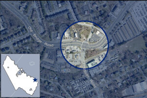
This post follows up on the comments we previously submitted in response to the December 8, 2021 Design Public Hearing for Prince William County DOT’s Route 234-Brentsville Road Interchange Project.

On March 18, 2022, the County released this followup video presentation on the proposed project design.   County DOT staff are willing to at least partly addresses three concerns with the proposed trail connections that were raised at the Design Public Hearing:

1) In response to public comments from Active Prince William and others, the County is now studying the cost feasibility of a new, dedicated trail bridge over Rte 234, just east of the interchange, to directly connect the existing trails along Route 234 and Route 294.   If this trail bridge can be added without the project exceeding it’s $55 million budget, it will be included in this project.   Otherwise, it probably won’t.

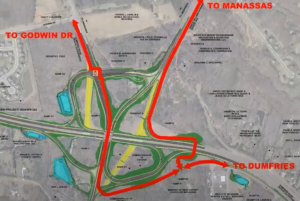
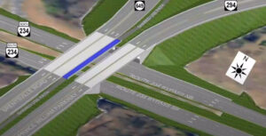
2) In response to safety concerns raised by many about the four proposed closely spaced at-grade trail crossings of free-flowing highway ramps near Route 294 and Bradley Cemetery Way in the northeast corner of this project, those hazardous at-grade trail crossings may not be built, at least if the added trail bridge discussed above is actually built.    However, this change would produce a long, circuitous trail route between the western legs (Route 234 Bypass and Route 234 Business) and eastern legs (the existing trails along Routes 234 and 294) of this interchange (shown in the top image above).

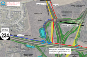
3) In response to objections that the design completely omits the long-planned trail along the Route 234 Bypass that should join the existing trails along Route 234 and Route 294,  the design team has identified a future location for this trail along the northwestern edge of the interchange (see the blue line in the second image above).

However, all trail connections to and from Route 234 Business and the long-planned future trail along the Route 234 Bypass (aka Route 234 North) would still require a two-stage at-grade crossing of 12 signalized traffic lanes plus one free-flowing right-turn lane at the rebuilt intersection of Bradley Cemetery Way and Rte 234 Business plus a second at-grade trail crossing of a free-flowing highway ramp at the south side of the interchange (at the on-ramp from Brentsville Road) .  Those remaining design flaws would still create considerable delays and hazards for trail users.

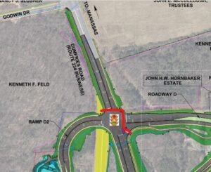
Under Prince William DOT’s revised design for this interchange, this slow and hazardous crossing of 13 traffic lanes at two legs of the signalized intersection of Bradley Cemetery Way and Route 234 Business would remain.  All trail access and egress from either Route 234 Business or the future trail along the Route 234 Bypass would need to use this routing to join either of the existing trails along Route 234 and Route 294 or Brentsville Road.

As a followup proposal, we suggest routing the long-planned trail along the Route 234 Bypass along the north side of Route 234 (per the second image from the top), connecting that trail to both the existing Route 294 Trail to the east and to a new shared-use path along the west side of Route 234 Business (where the existing pavement, depicted in yellow, is planned for removal).   This trail (depicted with a red line in that image) would pass underneath both new roadway overpasses being built to carry Brentsville Road and Route 294 over Route 234 and could also pass underneath three single-lane interchange ramps inside box culverts (see the light blue circles).

Under our proposal, the long-planned trail along the Route 234 Bypass would run along the north side of Route 234 and pass under both planned roadway bridges.


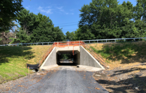
Three short box culverts could be used to route our proposed trail along the north side of the Route 234 Bypass beneath three one-lane interchange ramps.  Only one such box culvert would be needed for the connection to Route 234 Business.

Our proposed design eliminates all at-grade trail-roadway crossings, except to reach Route 234 Business.  However, by building a shared-use path along the west side of Route 234 Business (connecting to Godwin Dr), where only a sidewalk is currently planned, trail users would be required to cross only 5-lanes of stopped traffic at just the western leg of the signalized intersection of Bradley Cemetery Way and Route 234 Business, not 12-lanes of stopped traffic plus one lane of free-flowing right-turning traffic at two separate legs of that intersection.

Our proposal could also lower the cost of this project by eliminating the need to include a 14-foot wide shared-use path on the proposed Brentsville Road bridge.

Active Prince William believes that first-class, safe and direct trail connections for all five legs of this interchange can and should be provided within this project’s existing budget of $55 million.

Tour of Prince William Bicycling Event, July 23, 2022

Participate in the

2022 Tour of Prince William

to benefit the 501(c)(3) Prince William Trails and Streams Coalition and the 501(c)(3) Prince William Historic Preservation Foundation

When:  Saturday, July 23, 2022

Start time:  7:00 – 9:00 a.m. (no mass start)

Starting Location:  Brentsville Courthouse Historic Center
12229 Bristow Road, Bristow, VA 20136

Courses:  20-mile and 62-mile (metric century) rides

Cost:  $40 by May 31, $45 by June 30, $50 by July 22, and $55 in person July 23.

Course Description:  The courses introduce bicycle riders to the wide variety that is Prince William County.  Wind through urban, suburban, exurban, rural, forested, town, flat, and hilly areas.  Bicycle riders will visit two of Prince William County’s historic properties.

Registration opens April 11, 2022, and additional information is available now at www.tourofprincewilliam.org

Celebrate Bike to Work Day on Friday, May 20

Registration is now open for Metropolitan Washington’s Bike to Work Day 2022 on Friday, May, 20.

This FREE event features roughly 100 pit stops in DC, MD, and VA, each with FREE giveaways, food, and beverages, while supplies last.

The first 15,000 who register for the event online and arrive at a pit stop by bike will also receive a FREE event T-shirt.

This year’s event features pit stops at the following eight locations in greater Prince William:

Chinn Aquatic & Fitness Center (morning & afternoon)

Town of Dumfries, Simpson Community Center

George Mason University, Manassas campus, outside Freedom Aquatic & Fitness Center

Kelly Leadership Center, Independent Hill

City of Manassas – VRE Station

City of Manassas Park – VRE Station

Rippon Landing VRE Station

Woodbridge – VRE Station

Start Friday, May 20 with a healthy bike ride, and join the fun.  Celebrate and promote clean, healthy, affordable, and joyful transportation; meet fellow bike commuters, enthusiasts, and supportive officials; collect bike-to-work-day swag; and enjoy free breakfast snacks and beverages.  Some pit stops will also have free bicycle inspections and adjustments.  Register online now!

Local Media Coverage:

Occoquan District Transportation Town Hall, March 10, 6:30-8 PM

From https://occoquandistrict.net/event/mobility-matters-transportation-projects-in-the-occoquan-district/:

A number of projects are in the works to improve mobility in the Occoquan District, making it faster and safer to get where you are going, whether by car, by bike, or on foot. Supervisor Kenny Boddye has invited representatives from Prince William County Department of Transportation to provide residents with updates and answer questions on projects such as:

  • Old Bridge Road/Occoquan Road Realignment (Funded; Design Public Hearing on Feb. 3)
  • Summit School Road Extension (Funded)
  • Old Bridge Road Sidewalk – Tackett’s to Minnieville (Funded)
  • 123/Old Bridge Road Interchange (Under Study)

Click here to register for this Virtual Town Hall and to submit questions in advance. By logging into YouTube during the event, you can also participate in a live, moderated chat. After registering, please let others know about this community conversation!

Our Comments on the Old Bridge Rd/Occoquan Rd Intersection Project

On February 3, 2022, the Prince William County Department of Transportation held a Design Public Hearing for its $11.85 million project to straighten the curve on Old Bridge Road near its intersection with Occoquan Road.   Below are Active Prince William’s written comments on the proposed design of that project.  View the public hearing brochure and the public hearing presentation to see the proposed design.


Active Prince William submits the following comments for the Design Public Hearing for the above-referenced project.  Our all-volunteer organization seeks improved active mobility and public transportation throughout greater Prince William, to create more livable, equitable, and sustainable communities.

Our concerns with the proposed design for this intersection-reconstruction project can be summarized as follows: 1) lengthened crosswalks, 2) inadequate replacement sidewalks, 3) lack of bicycling accommodations, and 4) excessive design speeds.

Although framed as a “safety improvement”, this project does little to make walking, bicycling, or transit access safer.  At the same time, this project would promote speeding and add unnecessary vehicle capacity.

According to the traffic crash reports compiled by the Virginia Department of Motor Vehicles, Prince William County experienced a total of 804 traffic crashes involving pedestrians or bicyclists during the past decade (2012-2021), resulting in 232 severe injuries and 53 deaths among people walking or bicycling.  Undoubtedly, the excessive design speeds on Prince William County’s multilane arterial roadways are largely responsible for this carnage affecting people walking and bicycling, while also causing many additional deaths and severe injuries to the drivers and occupants of motor vehicles.

According to VDOT’s 2019 traffic count data, Old Bridge Road (VA 641) had an AADT of 53,000 west of Occoquan Road and an AADT of 45,000 east of Occoquan Road, whereas Occoquan Road (VA 906) had an AADT of 13,000 south of Old Bridge Road and an AADT of 2800 north of Occoquan Road.  However, those traffic volumes will likely decrease once the southbound bottleneck on I-95 south of Mile-Marker 160 is fixed.

Lengthened Crosswalks

The proposed design would lengthen all three marked crosswalks at this intersection.  With the added right-turn lane on eastbound Old Bridge Road, the Old Bridge Road crosswalk would become eight lanes wide.  The crosswalk across the southern leg of Occoquan Road would remain six lanes wide, and the crosswalk across the northern leg of Occoquan Road would now cross four lanes of traffic, including the separated right-turn pocket from westbound Old Bridge Road.

To help mitigate the adverse impacts of those longer crosswalks, the design should create protected median pedestrian refuges in each crosswalk.  In addition, whenever pedestrian crossing signals are activated, leading pedestrian intervals should be triggered to give the crossing pedestrians a head start over both right-turning and left-turning vehicles.

Moreover, serious consideration should be given to not adding right-turn lanes on eastbound Old Bridge Road and/or southbound Occoquan Road and to eliminating one or two of the existing turn lanes on northbound Occoquan Road.

On eastbound Old Bridge Road, the existing curb lane approaching Occoquan Road should be redesignated for right turns only, rather than adding a new right-turn-only lane.  The VDOT traffic data show that the Old Bridge Road leg east of Occoquan Road carries 8,000 fewer vehicles/day than the Old Bridge Road leg west of Occoquan Road, indicating that two eastbound straight-through lanes are sufficient at that location.

On southbound Occoquan Road, which carries only 2800 vehicles/day, a short right-turn pocket with a pork chop island pedestrian refuge could be created as an alternative to the proposed new right-turn-only lane.

On northbound Occoquan Road, one of the two existing left-turn-only lanes could be eliminated and/or the right-turn lane replaced with a short right-turn pocket with a pork chop island pedestrian refuge.

The overall objective should be to shorten, not lengthen, the three existing crosswalks.  

 Inadequate Replacement Sidewalks

The proposed replacement sidewalks, along both sides of both roads, are only five feet wide and separated from the roadway by only a four-foot-wide grass buffer.  While this does represent a modest improvement over the existing deficient sidewalks, the replacement sidewalks should be both wider and separated farther from the roadway.

Walking just four feet away from a busy multilane roadway is noisy and unpleasant, and five-foot-wide sidewalks do not comfortably accommodate two-way pedestrian traffic or walking two abreast.

Furthermore, in winter, snow and ice plowed onto such narrowly buffered sidewalks from the adjacent roadway can render such sidewalks impassable for many days and weeks.  In the summer heat, the absence of street trees growing within a viable tree-planting strip makes walking without shade miserable.

In addition, the proposed sidewalks are devoid of much-needed pedestrian amenities such as benches, pedestrian-scale streetlights, and bus shelters.

The realignment of Old Bridge Road will abandon much of the existing roadway along the south side of that road.  That abandoned roadway provides ample right of way to build a wider and better-separated replacement sidewalk at that location.

For future projects, the County should revise its road-design standards to provide better pedestrian accommodations.

Lack of Bicycling Accommodations

Old Bridge Road and Occoquan Road both lack bicycling accommodations, so they are not Complete Streets.  Without even a sidepath (a wide sidewalk intended for both bicycling and walking), these roadways should be restriped or rebuilt with at least conventional (striped) on-road bicycle lanes.

Besides improving bicycling conditions, conventional on-road bicycle lanes enhance the pedestrian environment by increasing the separation between the sidewalk and vehicle traffic and by shortening pedestrian crossings of the vehicle lanes at intersections.

Old Bridge Road has overly wide 12-foot travel lanes, the width used on Interstate highways with 70+ MPH design speeds.  Thus, bike lanes could easily be retrofitted on Old Bridge Road at any time, simply by restriping its six 12-foot-wide travel lanes as six 11-foot-wide travel lanes and reallocating the freed-up space for bike lanes.  When added to the existing two-foot-wide concrete gutter pans, the freed-up space would produce five-foot-wide bicycle lanes, meeting the AASHTO minimum width.  Some additional space for bike lanes (or wider medians) could be created by narrowing all left- and right-turn lanes to 11 feet as well.

Since Occoquan Road has only 11-foot lanes, narrowing those lanes to create bike lanes—while still somewhat feasible—might not be approved by VDOT.  However, it is readily feasible to modify the current project to redesign the rebuilt north leg of Occoquan Road to incorporate five-foot bike lanes in both directions.

The south leg of Occoquan Road has at least four travel lanes between Old Bridge Road and US-1 yet had an AADT of only 13,000 in 2019.  This roadway is thus a prime candidate for a four-lane to three-lane road diet, producing a roadway with only one travel lane per direction, a two-way left-turn lane in the center, and two one-way bicycle lanes.

Such roadway reconfigurations, if managed by VDOT during scheduled roadway resurfacing, are highly cost effective and are accomplished at no cost of the County.  Prince William County should coordinate with VDOT to retrofit bike lanes on the entirety of Old Bridge Road and of Occoquan Road whenever those roadways are next scheduled for periodic resurfacing.  If either roadway is reconfigured before the current project is completed, the current project should ensure that those bike lanes are incorporated into the final roadway striping plan for the rebuilt segment.

Excessive Roadway Design Speeds

At the public hearing, project staff reported that the proposed design would preserve the present 35 MPH posted speed limit on Old Bridge Road and aims for a 40 MPH design speed.  Those speeds are too high for an arterial roadway through a commercial corridor with nearby residential neighborhoods and a large park-and-ride facility.

Project staff also noted the traditional highway engineering practice of posting speed limits based on the observed speeds of the motorists that use the roadway (i.e., the 85th percentile speed).  Such an antiquated and dangerous practice is the opposite of a safe systems approach; namely, engineers should select roadway design speeds and standards that allow pedestrians and bicyclists to survive most collisions with motor vehicles.

Narrowing the lanes on Old Bridge Road to 11 feet (or less) would be one simple step to reduce the excessive design speed on this roadway.  In addition, the curb-return radii at all corners of this intersection should be reduced to conform to the 30 MPH design speed that is appropriate for this roadway.

Thank you for considering our comments as you finalize the design of this project.

Sincerely,

Allen Muchnick and Mark Scheufler, co-chairs Active Prince William

###

« Older posts Newer posts »