Advancing active mobility in greater Prince William, Virginia

Tag: bike lanes

Hoadly Road Needs Proper Bike Lanes

We recently learned that the Prince William County Department of Transportation will soon conduct a Hoadly Road Planning Study to identify priorities for funding and then building segments of a continuous shared-use path (i.e., a 10-foot wide asphalt sidepath) along Hoadly Road, between the Prince William Parkway (Route 294) and Dumfries Road (Route 234).  Hoadly Road currently lacks any sidepath, except along the 0.4-mile segment between Dale Boulevard and Spriggs Road.

Active Prince William strongly supports establishing a continuous sidepath along at least one side of Hoadly Road, especially since such shared-use pedestrian facilities would link Prince William County’s two major sidepaths–along Routes 234 and 294.

However, the Mobility Chapter of the current Prince William County Comprehensive Plan (Pathways to 2040), which the Board of County Supervisors adopted in December 2022, is deficient in not also calling for on-road bicycle lanes along Hoadly Road (see page 73 here).

There is no inherent reason why highway corridors should include only one type of bicycle facility–e.g., only a sidepath–especially since conventional bike lanes can be retrofitted on multi-lane roadways much more quickly and inexpensively and since having both on-road and off-road bicycle facilities could best serve our highly diverse population of bicycle riders.   In addition, bike lanes are more readily and promptly cleared of snow and ice after winter storms.

Furthermore, bike-lane retrofits have the added benefits of reducing motorist speeding (by reducing travel lane widths) and of increasing the safety and comfort of people traveling on the sidewalks or sidepaths (by increasing the noise and wind buffer from vehicular traffic).

Hoadly Road currently has an excessively high design speed, a posted speed limit of 50 MPH, and poor pedestrian infrastructure.  Consequently, according to Virginia’s publicly searchable traffic crash database, over the past decade (2014-2023 calendar years), Hoadly Road was the site of 403 traffic crashes, 310 crash-associated injuries, and 4 traffic fatalities.  Retrofitted bike lanes on Hoadly Road would help alleviate those unsafe conditions for all modes of travel.

When widened some decades ago, Hoadly Road gained continuous wide paved shoulders that were well suited for bicycling, and at least some of those shoulder segments were subsequently marked as bike lanes.

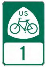
US Bicycle Route 1 (USBR 1) is a Maine-to-Florida bicycling route–primarily intended for experienced bicycle travelers–that has existed for decades.  USBR1 in Virginia, upon VDOT’s written application, was designated by the American Association of State Highway and Transportation Officials (AASHTO) back in 1982, more than 40 years ago.  Although USBR1 through Prince William County was originally aligned with Minnieville Road, between Old Bridge Road and Dumfries Road, VDOT and Prince William County largely failed to include appropriate bicycle facilities along much of Minnieville Road during the ensuing decades. as segments of Minnieville Road were sequentially widened to accommodate increased development and traffic.

More than a decade ago, VDOT commissioned a study by a transportation consulting firm to re-evaluate the routing of US Bicycle Route 1 through Northern Virginia, including Prince William County.  As a result of that study, USBR1 was officially realigned to follow a segment of the Prince William Parkway and all of Hoadly Road, to avoid the segment of Minnieville Road north of Cardinal Drive that still lacks bicycle facilities.

As noted on page 11 of that USBR1 realignment study report (emphasis added below):

Although less direct than the other alternatives, the recommended alternative (via Minnieville Road, Prince William Parkway, and Hoadly Road) offers a higher average BLOS [Bicycle Level of Service] (B), primarily the result of lower ADT [average daily traffic] and wider shoulders. The route segment along Minnieville Road and Prince William Parkway has high ADT (up to 45,000 vehicles per day), but also provides shared use paths or wide shoulders for much of the duration. Meanwhile, Hoadly Road has approximately 13,000 to 23,000 vehicles per day and provides 8‐foot shoulders along many segments.

Google Street View reveals that various segments of Hoadly Road currently do have marked bike lanes, but these are discontinuous and often inappropriately situated on the right side of long right-turn-only lanes, such as here, here, here, and here.   Glaring deficiencies in Hoadly Road’s “bike lanes” were noted by a resident back in 2010 [mislabeled a “bike path” in that blog post].

Since the entirely of Hoadly Road has been the designated alignment of US Bicycle Route 1 for nearly the past decade, Active Prince William asks that VDOT and Prince William County proactively collaborate to retrofit continuous and well-designed bike lanes–and, ideally, buffered or separated bike lanes–along all of Hoadly Road at the earliest possible opportunity.

We also recommend adding the planned Hoadly Road sidepath as a designated segment of the National Capital Trail Network (NCTN) when the National Capital Region Transportation Planning Board again updates its NCTN map in the coming year.
Our Input for the Route 234-Clover Hill Road Bowtie Intersection

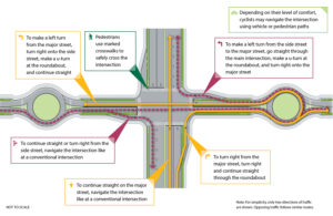
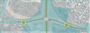
2017 Concept for a Clover Hill Road/Prince William Parkway “Bowtie” Intersection

Recently, the Prince William County Department of Transportation asked for our feedback on their proposed preliminary design for rebuilding the intersection of the Prince William Parkway (Route 234) and Clover Hill Road near Manassas as an “innovative” bowtie intersection, where all direct left turns are eliminated and instead accommodated via two roundabouts on the minor cross street.   Our reply is posted below.   We will track this upcoming project in the coming years as the design is refined for construction.


Thank you for soliciting Active Prince William’s input on how the redesigned intersection of Clover Hill Road at the Prince William Parkway can best serve people walking and bicycling.

Conventional On-Road Bike Lanes Are Appropriate for Clover Hill Road

Clover Hill Road provides an important low-traffic bicycling connection between the City of Manassas (and adjacent residential neighborhoods within the County) and Manassas Regional Airport and points west, including the Broad Run VRE station and the new Route 28 shared-use path that now extends though Bristow all the way to Nokesville.  On the southwest side of Route 234, Clover Hill Road provides critical bicycling access to a network of low-traffic, bicycling-friendly roads within and near Manassas Regional Airport, including Harry J Parrish Blvd. Wakeman Drive, Observation Drive, Piper Lane, Residency Road, Pennsylvania Avenue, Carolina Drive, and Gateway Blvd.

As such, Clover Hill Road is eminently useful for bicycle commuting to employment sites within and near the airport, to the Broad Run VRE station, and to points west in Bristow.  In addition, Clover Hill Road and the low-traffic roads within and around the airport are used extensively for recreational bicycling on evenings and weekends.

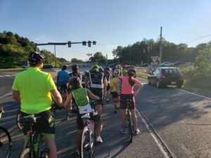
Bicyclists on Bull Run Bicycle’s Tuesday evening shop ride wait to cross Route 234 at Clover Hill Road. To avoid hazardous right-turning traffic on both sides of this intersection, the group waits for a green traffic signal in the left travel lane of Clover Hill Road.

Both City of Manassas roadways that connect to this segment of Clover Hill Road–i.e.. Clover Hill Road from Godwin Drive to Wellington Road and Godwin Drive from Clover Hill Road to Hastings Drive–already have conventional on-road bike lanes.  Thus, in addition to including sidewalks for pedestrians, the entire redesigned segment of Clover Hill Road should include conventional on-road bike lanes in both directions.

Note that VDOT’s website that describes bowtie intersections includes conventional on-road bike lanes on all four legs of that intersection (see the illustration copied below).

Since, as in the above illustration, the proposed design features dedicated right-turn-only lanes on Clover Hill Road at both approaches to the Prince William Parkway, it would be vital to install the bike lanes at both approaches to the Prince William Parkway between the straight-through travel lane on the left and the right-turn-only lane at the curb.

Within the roundabouts, the bike lanes–if any–should be on the far right and could be buffered or physically separated from roadway traffic.  Alternatively, especially if right-of-way is constrained at the roundabouts, the bike lanes could be discontinued within the roundabouts and bicyclists encouraged to navigate the roundabouts as either a driver centered within the travel lane or (using strategically placed curb ramps for access and egress) as a pedestrian using the sidewalk.

However, upon exiting each roundabout, right-turning motorists should be directed to yield to any bicycle traffic ahead and to carefully merge right across the continued bike lane to enter the emerging right-turn-only lane before reaching either the Parkway (along both southbound and northbound Clover Hill Road) or Godwin Drive (along northbound Clover Hill Road).

Please note that these same conflicts between right-turning motorists and straight-through bicyclists presently exist at the current Clover Hill Road/Route 234 Intersection in the absence of any bike lanes and that appropriate traffic engineering measures, involving pavement markings and signage, can optimize the safety of all road users.

Design This Intersection to Safely Accommodate the Future Shared-Use Path Along Route 234

Although this project won’t construct the long-planned missing shared-use path along Route 234, the design of this intersection should not preclude its future construction and should also ensure that pedestrians and bicyclists using that shared-use path can cross Clover Hill Road safely.  As a designated segment of the National Capital Trail Network, a continuous, high-quality shared-use path along Route 234 should be a priority for Prince William County.

Unobstructed right-of-way should be acquired and preserved as part of this project to accommodate the future Route 234 shared-use path, and the project design should ensure that the route and future design of this path would not be blocked or compromised by noise barriers, above-ground or buried utilities, or roadside signage, traffic signals, or street lighting.  Until the county decides whether this path will be constructed on the northeast or southwest side of Route 234, right-of-way should be reserved for the future shared-use path on both sides.

In addition, the intersection design should ensure that the future Route 234 Trail will have a safe, at-grade crossing of Clover Hill Road, presumably coordinated with the same traffic signal that regulates the Route 234 traffic.

Eliminate High-Speed Right-on-Red Turning Movements from Route 234 onto Clover Hill Road

Unlike VDOT’s model bowtie intersection illustrated above, the currently proposed intersection design incorporates two free-flowing, high-speed, right-turning movements, using pork-chop islands, for Route 234 traffic to enter Clover Hill Road.  We believe this currently proposed design feature would seriously endanger both 1) bicyclists and pedestrians crossing Route 234 at Clover Hill Road and 2) the users of the future Route 234 Trail crossing Clover Hill Road.

Vulnerable, non-motorized road and trail users who are crossing either roadway on a green traffic signal should not be endangered by high-speed traffic that is simultaneously turning right-on-red at near-freeway speeds at these pork-chop islands.  While a decision to completely ban all right-turn-on-red movements at this intersection might best be made by expert traffic engineers, we firmly believe that free-flowing right-on-red movements would be dangerous at this intersection and should not be promoted by design features such as pork-chop islands.

Instead, vehicle traffic entering Clover Hill Road from Route 234 should be encouraged to slow to the 25 MPH posted speed and carefully merge into the single travel lane approaching the roundabout, while bicyclists who have just crossed Route 234 on a green signal must merge into the bike lane at the right edge of the roadway.

Again, careful pavement marking and signing would help all road users safely negotiate these conflicts, whereas a design that promotes high-speed right-on-red vehicle traffic would endanger vulnerable road users.

Bicyclists and pedestrians crossing Route 234 at Clover Hill Road on a green traffic signal would primarily be endangered by motorists turning right-on-red from Route 234 at the far side of their crossing.  By contrast, users of the future Route 234 Trail crossing Clover Hill Road on a green traffic signal could encounter both motorists turning right-on-green from Route 234 as well as motorists turning right-on-red from Clover Hill Road.   All such right-turning movements would be safer if the design encourages motorists to slow or stop completely before entering a crosswalk and turning into the path of vulnerable road users.  Partial traffic signal phasing, such as leading pedestrian intervals, could also make these crossings safer.

Clover Hill Road is a local street posted for 25 MPH, and there is no compelling need to promote free-flowing right-turn-on-red vehicle movements onto Clover Hill Road.

The 2019 AADT for all connected local roadways (i.e., Clover Hill Road, Godwin Drive, and Harry J Parrish Blvd) ranges from 2100 to 4700, so Clover Hill Road only needs one travel lane per direction between intersections. The proposed design includes a grassy median along Clover Hill Road, but there’s no compelling need for a grassy median on a road posted for 25 MPH, and that grassy median is about a full-lane wide on the segment approaching Godwin Dr.

Active Prince William also supports the inclusion of a shared-use path along this entire segment of Clover Hill Road; however, such a path would not connect to any existing path along Clover Hill Road, Godwin Drive or Harry J. Parrish Blvd, and it appears that the long-planned path along the Route 234 Bypass won’t be built for the foreseeable future.  Thus, a shared-use path seems less essential, especially on the airport side of Route 234, provided that both sides of Clover Hill Road will have sidewalks and bike lanes.

If spatial or terrain constraints would otherwise preclude the addition of both on-road bike lanes and sidewalks along Clover Hill Road in both directions, consideration should be given to narrowing or eliminating the grassy medians.

Thank you for considering our input.

###

The City of Manassas is Poised to Revamp Grant Ave with the City’s First Road Diet, Citing Pedestrian Safety Concerns

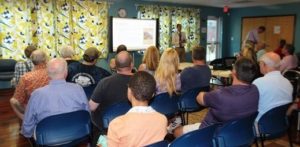
The City of Manassas is in the planning stages of a redesign of Grant Avenue, a road considered the southern gateway to downtown Manassas. Citing pedestrian safety and safe routes to schools, City staff are considering a road diet from 4 to 3 lanes with improved pedestrian sidewalks and crossings. A public meeting was held on 29 June with additional public engagement in the planning process to come in the future. Implementation of the Grant Ave Streetscape Project will also enable the city to move forward with smart growth re-development on the southern side of the city.

Streetscape Meeting

Manassas Grant Ave Streetscape Meeting

At the public meeting on 29 June, there was considerable staff, consultant, and community support for implementing a four-lane to three-lane road diet to improve walking and bicycling conditions, enhance bus stops, and increase aesthetics without significantly degrading motoring. Mayor Parrish, three current City Council members, and senior City staff were present at the meeting.

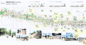
Existing Condition Comments

Manassas Grant Ave Streetscape Existing Condition Comments

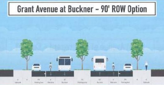
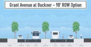
At the meeting, staff guided interested individuals in using the Streetmix computer program to design alternative cross sections for Grant Ave.  While conventional bike lanes are eminently feasible and should be adequate for many bike riders with a road diet’s traffic-calming influence and a lowered 25 MPH speed limit, it was clear that the current street right of way is constrained, and expanding the sidewalk areas to include planting strips with street trees, urban street lamps, and bus shelters is an important “competing” priority that may preclude adding buffered or separated bicycle lanes.

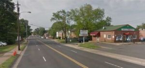
View near Brent St.

Manassas Grant Ave view near Brent St.

While a simple road diet can often be accomplished using only maintenance funds to repave and re-paint the new lane configuration, expanding the sidewalks and planting strips, undergrounding the currently overhead utilities, and adding bus shelters, urban street lights, street furniture, trees, and other landscaping along Grant Ave will necessitate considerable construction funds.

The Initial planning and design for the project has been funded, but there’s not yet any funding allocated for construction, and thanks to HB 2 and HB 599, which target road capacity expansions, neither the Virginia Commonwealth Transportation Board (CTB) nor the Northern Virginia Transportation Authority (NVTA) are likely to provide any money for a road diet.  If construction will be locally funded, it’s unlikely that the curbs will be moved, so as to greatly reduce construction costs.  At the meeting, Active Prince William advocated for alternatives–including buffered bike lanes–that could fit within the existing roadway.

Example Road Profile

Grant Ave Streetscape Example Road Profile

For more information, visit the City’s project page [http://www.manassascity.org/grantave], where you can sign up for project updates, and view the meeting presentation which provides background information and describes how the meeting was conducted.