On March 31, 2022, Active Prince William submitted the following comments to the City of Manassas regarding its proposed Mathis Avenue Improvement Project:
Re: Mathis Avenue Improvement Project (T-086) Public Meeting Comments
On behalf of Active Prince William, I’m writing to submit the following comments in response to the March 17, public meeting for the above-referenced project. Our all-volunteer organization seeks improved active mobility and public transportation throughout greater Prince William, to create more livable, equitable, and sustainable communities.
An Improved Public Process for Transportation Project Development
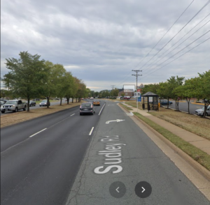
We sincerely appreciate the improved process used to involve the public at the 30% design stage for this capital transportation project, which included both a February 23 virtual public meeting and an in-person meeting held on March 17. This public involvement process is far better than the one used by City staff for its recent Sudley Road Third Lane Project, which excluded all public input before preliminary engineering was at least 90% complete (including when that project had been re-scoped substantially twice, in December 2017 and in February 2021). We hope this public comment opportunity reflects a permanent policy change to proactively involve the public in all City transportation projects going forward, ideally starting at the project scoping stage.
The Proposed Design is a Reasonable Interim Aesthetic Improvement but Lacks Essential Pedestrian Amenities for a Vibrant, Mixed-Use Street
As a final condition for a revitalized Mathis Avenue as a mixed-use, pedestrian-oriented street–ideally with robust bus transit service–the proposed design would be a major disappointment. However, as an interim improvement intended to transform the appearance of this somewhat desolate commercial street and to promote future mixed-use redevelopment at minimal cost, this project does appear to have merit.
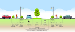
In particular, the proposed design provides sidewalks that are too narrow for comfortable two-way walking, are too close to the roadway, and lack street trees and pedestrian-serving street furniture in what should be much wider curbside planting strips and furniture zones. In addition, the sidewalks are interrupted with frequent curb cuts, where motor vehicle cross flows impede safe and comfortable walking.
However, considering the need for Mathis Avenue to continue serving the existing auto-oriented businesses beside it, especially along the east side of this street, until redevelopment occurs some years in the future, the imperative to minimize right of way takings and to preserve the existing curb cuts is understandable.
To effectively promote the specific forms of redevelopment that the City seeks and to ensure that this redevelopment incorporates the necessary mobility infrastructure to equitably support that redevelopment, the City’s Department of Planning and Community Development should undertake a robust community-based planning process to develop a detailed form-based zoning code for the Mathis Avenue corridor. Form-base zoning codes are a proven tool to effectively promote the specific forms of redevelopment desired by localities.
Bicycling Accommodations and Roadway Design Speed
The lack of bike lanes (or any alternative bicycle facilities) in this project is disappointing but is also understandable since the existing curbs are not being moved to keep the existing storm sewer infrastructure in place, to minimize costs and commercial property impacts. However, without bike lanes, the construction of raised medians will degrade bicycling conditions substantially, and those degraded conditions are unlikely to be remedied by a future roadway widening when the corridor is eventually redeveloped.
Presently, motorists can readily safely overtake people riding bicycles on Mathis Avenue by passing in the two-way central left-turn lane. The raised medians, however, will prevent motorists from overtaking bicycle riders, who typically travel at 10-16 MPH. Thus, people riding bicycles on Mathis Avenue will serve as slow-moving traffic-calming devices. This roadway change will make bicycling unpleasant for nearly all riders and will subject people riding bicycles to increased harassment from frustrated motorists who are unable to pass. Moreover, since Mathis Avenue would probably not be rebuilt with added bike lanes when redevelopment occurs in the future, this degradation of bicycling conditions on Mathis Avenue is likely permanent.
The fact that nearby Portner Avenue is designated as a bicycle route is no reason to degrade bicycling conditions on Mathis Avenue. While many through bicyclists already prefer to travel on Portner Avenue, only Mathis Avenue serves the businesses and jobs located along Mathis Avenue, and people will someday live on this segment of Mathis Avenue too.
Thus, for both bicycle access and pedestrian safety, this project should strive to reduce the design speed for Mathis Avenue–and ideally the posted speed limit–to 20 MPH or below. The raised median with street trees—and especially street trees in future curbside planting strips and future taller buildings closer to the roadway—should encourage motorists to drive more slowly on Mathis Avenue, but other design changes are needed too.
Shorter curb-return radii at corners and narrower sidewalk curb cuts would help reduce motor vehicle speeds, and electronic speed-feedback signs paired with posted speed limit signs (dynamic speed displays) would warn speeding motorists to slow down. In addition, shared-lane markings (aka “sharrows”) centered in each travel lane would inform both motorists and bicycle riders that this is a shared roadway.
More Visible and Shorter Crosswalks
One notable design feature that should be changed is the proposed use of brick-colored stamped asphalt crosswalks. While intended to impart historic charm, brown-colored crosswalks are far less conspicuous to motorists than modern high-visibility and reflective thermoplastic crosswalk markings. The primary purpose of marked crosswalks is to alert motorists to the likely presence of crossing pedestrians, encouraging drivers to slow down, look for, prepare to yield to, and stop for pedestrians who may be crossing the roadway. A faux-brick aesthetic is far less important than the safety of people who are walking across the street.
In addition, the final design of each intersection should pay particular attention to shortening the length of all crosswalks to the extent feasible and to install two separate curb ramps for the crosswalk landings at each corner. The present design includes a single combined curb ramp at the southeast corner of Mathis Avenue and Sudley Road and at all four corners of Mathis Avenue and Liberia Avenue, the two on the north side not being rebuilt.
Designing shorter curb-return radii at all intersection corners, as suggested above to reduce the roadway design speed, would also reduce the crosswalk lengths at those intersections.
Consider Short Left-Turn Lanes at Reb Yank Drive and Carriage Lane
The advertised design does not include any space in the center of the roadway (beyond the intersection itself) to store vehicles waiting to turn left at Reb Yank Drive (from both directions) or southbound at Carriage Lane. While shortening the raised medians to add short left-turn pockets at those three locations could increase travel speeds along Mathis Avenue and could also remove the proposed median refuges for crossing pedestrians at those unsignalized intersections, it may be prudent to add those left-turn pockets to smooth traffic flow, reduce traffic congestion, and lower the incidence of rear-end collisions at those locations. However, if traffic studies have already documented that those left-turn pockets are unnecessary, then please retain them.
Thank you for considering our comments as you finalize the design of this project.
