Advancing active mobility in greater Prince William, Virginia

Tag: Prince Willam County (Page 1 of 2)

Our Statement At The VDOT NoVA District’s Spring 2023 Joint Transportation Meeting


Annual Joint Transportation Meeting for Northern Virginia, May 1, 2023
Statement of Allen Muchnick, Member of the Virginia Bicycling Federation
and Active Prince William Boards of Directors

Good evening.  I’m Allen Muchnick.  I live in the City of Manassas, and I serve on the boards of the Virginia Bicycling Federation and Active Prince William, statewide and sub-regional active transportation advocacy organizations, respectively.

We thank VDOT for recently re-filling its statewide bicycle and pedestrian planner position and for staffing a new statewide trails office.  We look forward to seeing those offices advance safe active mobility.  We believe it’s time to review and update both VDOT’s 2011 State Bicycle Policy Plan and the CTB’s 2004 Policy for Integrating Bicycle and Pedestrian Accommodations.

I commend VDOT’s NoVA District Office for initiating a study to estimate the cost to complete all locally planned but unfunded bicycle and pedestrian facilities within the NoVA District.  While most NoVA localities have robust active mobility plans and even Vision Zero programs, Prince William County still lacks both, so its official inventory of missing pedestrian and bicycle facilities is woefully incomplete.

Since 2010, VDOT’s roadway reconfiguration program has cost-effectively retrofit bike lanes and pedestrian crossing improvements on many dozens of roadways during scheduled resurfacing, especially in Fairfax County.  Prince William County, however, has largely ignored this enormous opportunity to improve the access and safety of its vulnerable road users.  We urge the County and VDOT to actively implement this program in our communities.

The alignment of US Bicycle Route 1 through Prince William County is a prime example where retrofitted bike lanes or paved shoulders are desperately needed.  Although AASHTO and VDOT established this route more than 40 years ago and a VDOT consultant re-evaluated the route’s alignment through NoVA nearly a decade ago, the bicycling conditions on several Prince William route segments are horrendous.  For example, the County’s online Bicycle Skill Level Map labels Old Bridge Road, part of Minnieville Rd, Aden Rd, and Fleetwood Dr—all lacking bicycle facilities and posted at 45-MPH–as “Roads to Avoid” and tags Hoadly Rd and Tanyard Hill Rd as “Low Comfort”.  VDOT’s 2015 Bicycle Level of Service Map for the NoVA District rated those segments similarly.  It’s long past time for VDOT and the County to fix these embarrassing and potentially deadly deficiencies.

To address the ongoing epidemic of pedestrian fatalities, VDOT should aggressively implement design-speed reductions and pedestrian safety improvements along its multi-lane commercial arterials.  VDOT and Prince William should also establish safer bike/ped crossings of I-95 and I-66 and extend the I-66 Trail, now being built in Fairfax County, over Bull Run to connect to both Balls Ford Rd and the Northern Virginia Community College’s Manassas campus.

In closing, we strongly support the recommended SMART SCALE, CMAQ, and RSTP awards for Manassas, Manassas Park, and Prince William County.

Thank you for this opportunity to comment.

###

Our Input for the Route 234-Clover Hill Road Bowtie Intersection

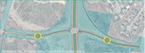
2017 Concept for a Clover Hill Road/Prince William Parkway “Bowtie” Intersection

Recently, the Prince William County Department of Transportation asked for our feedback on their proposed preliminary design for rebuilding the intersection of the Prince William Parkway (Route 234) and Clover Hill Road near Manassas as an “innovative” bowtie intersection, where all direct left turns are eliminated and instead accommodated via two roundabouts on the minor cross street.   Our reply is posted below.   We will track this upcoming project in the coming years as the design is refined for construction.


Thank you for soliciting Active Prince William’s input on how the redesigned intersection of Clover Hill Road at the Prince William Parkway can best serve people walking and bicycling.

Conventional On-Road Bike Lanes Are Appropriate for Clover Hill Road

Clover Hill Road provides an important low-traffic bicycling connection between the City of Manassas (and adjacent residential neighborhoods within the County) and Manassas Regional Airport and points west, including the Broad Run VRE station and the new Route 28 shared-use path that now extends though Bristow all the way to Nokesville.  On the southwest side of Route 234, Clover Hill Road provides critical bicycling access to a network of low-traffic, bicycling-friendly roads within and near Manassas Regional Airport, including Harry J Parrish Blvd. Wakeman Drive, Observation Drive, Piper Lane, Residency Road, Pennsylvania Avenue, Carolina Drive, and Gateway Blvd.

As such, Clover Hill Road is eminently useful for bicycle commuting to employment sites within and near the airport, to the Broad Run VRE station, and to points west in Bristow.  In addition, Clover Hill Road and the low-traffic roads within and around the airport are used extensively for recreational bicycling on evenings and weekends.
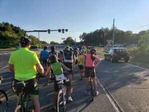
Bicyclists on Bull Run Bicycle’s Tuesday evening shop ride wait to cross Route 234 at Clover Hill Road. To avoid hazardous right-turning traffic on both sides of this intersection, the group waits for a green traffic signal in the left travel lane of Clover Hill Road.

Both City of Manassas roadways that connect to this segment of Clover Hill Road–i.e.. Clover Hill Road from Godwin Drive to Wellington Road and Godwin Drive from Clover Hill Road to Hastings Drive–already have conventional on-road bike lanes.  Thus, in addition to including sidewalks for pedestrians, the entire redesigned segment of Clover Hill Road should include conventional on-road bike lanes in both directions.

Note that VDOT’s website that describes bowtie intersections includes conventional on-road bike lanes on all four legs of that intersection (see the illustration copied below).
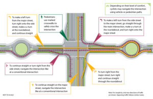
Since, as in the above illustration, the proposed design features dedicated right-turn-only lanes on Clover Hill Road at both approaches to the Prince William Parkway, it would be vital to install the bike lanes at both approaches to the Prince William Parkway between the straight-through travel lane on the left and the right-turn-only lane at the curb.

Within the roundabouts, the bike lanes–if any–should be on the far right and could be buffered or physically separated from roadway traffic.  Alternatively, especially if right-of-way is constrained at the roundabouts, the bike lanes could be discontinued within the roundabouts and bicyclists encouraged to navigate the roundabouts as either a driver centered within the travel lane or (using strategically placed curb ramps for access and egress) as a pedestrian using the sidewalk.

However, upon exiting each roundabout, right-turning motorists should be directed to yield to any bicycle traffic ahead and to carefully merge right across the continued bike lane to enter the emerging right-turn-only lane before reaching either the Parkway (along both southbound and northbound Clover Hill Road) or Godwin Drive (along northbound Clover Hill Road).

Please note that these same conflicts between right-turning motorists and straight-through bicyclists presently exist at the current Clover Hill Road/Route 234 Intersection in the absence of any bike lanes and that appropriate traffic engineering measures, involving pavement markings and signage, can optimize the safety of all road users.

Design This Intersection to Safely Accommodate the Future Shared-Use Path Along Route 234

Although this project won’t construct the long-planned missing shared-use path along Route 234, the design of this intersection should not preclude its future construction and should also ensure that pedestrians and bicyclists using that shared-use path can cross Clover Hill Road safely.  As a designated segment of the National Capital Trail Network, a continuous, high-quality shared-use path along Route 234 should be a priority for Prince William County.

Unobstructed right-of-way should be acquired and preserved as part of this project to accommodate the future Route 234 shared-use path, and the project design should ensure that the route and future design of this path would not be blocked or compromised by noise barriers, above-ground or buried utilities, or roadside signage, traffic signals, or street lighting.  Until the county decides whether this path will be constructed on the northeast or southwest side of Route 234, right-of-way should be reserved for the future shared-use path on both sides.

In addition, the intersection design should ensure that the future Route 234 Trail will have a safe, at-grade crossing of Clover Hill Road, presumably coordinated with the same traffic signal that regulates the Route 234 traffic.

Eliminate High-Speed Right-on-Red Turning Movements from Route 234 onto Clover Hill Road

Unlike VDOT’s model bowtie intersection illustrated above, the currently proposed intersection design incorporates two free-flowing, high-speed, right-turning movements, using pork-chop islands, for Route 234 traffic to enter Clover Hill Road.  We believe this currently proposed design feature would seriously endanger both 1) bicyclists and pedestrians crossing Route 234 at Clover Hill Road and 2) the users of the future Route 234 Trail crossing Clover Hill Road.

Vulnerable, non-motorized road and trail users who are crossing either roadway on a green traffic signal should not be endangered by high-speed traffic that is simultaneously turning right-on-red at near-freeway speeds at these pork-chop islands.  While a decision to completely ban all right-turn-on-red movements at this intersection might best be made by expert traffic engineers, we firmly believe that free-flowing right-on-red movements would be dangerous at this intersection and should not be promoted by design features such as pork-chop islands.

Instead, vehicle traffic entering Clover Hill Road from Route 234 should be encouraged to slow to the 25 MPH posted speed and carefully merge into the single travel lane approaching the roundabout, while bicyclists who have just crossed Route 234 on a green signal must merge into the bike lane at the right edge of the roadway.

Again, careful pavement marking and signing would help all road users safely negotiate these conflicts, whereas a design that promotes high-speed right-on-red vehicle traffic would endanger vulnerable road users.

Bicyclists and pedestrians crossing Route 234 at Clover Hill Road on a green traffic signal would primarily be endangered by motorists turning right-on-red from Route 234 at the far side of their crossing.  By contrast, users of the future Route 234 Trail crossing Clover Hill Road on a green traffic signal could encounter both motorists turning right-on-green from Route 234 as well as motorists turning right-on-red from Clover Hill Road.   All such right-turning movements would be safer if the design encourages motorists to slow or stop completely before entering a crosswalk and turning into the path of vulnerable road users.  Partial traffic signal phasing, such as leading pedestrian intervals, could also make these crossings safer.

Clover Hill Road is a local street posted for 25 MPH, and there is no compelling need to promote free-flowing right-turn-on-red vehicle movements onto Clover Hill Road.

The 2019 AADT for all connected local roadways (i.e., Clover Hill Road, Godwin Drive, and Harry J Parrish Blvd) ranges from 2100 to 4700, so Clover Hill Road only needs one travel lane per direction between intersections. The proposed design includes a grassy median along Clover Hill Road, but there’s no compelling need for a grassy median on a road posted for 25 MPH, and that grassy median is about a full-lane wide on the segment approaching Godwin Dr.

Active Prince William also supports the inclusion of a shared-use path along this entire segment of Clover Hill Road; however, such a path would not connect to any existing path along Clover Hill Road, Godwin Drive or Harry J. Parrish Blvd, and it appears that the long-planned path along the Route 234 Bypass won’t be built for the foreseeable future.  Thus, a shared-use path seems less essential, especially on the airport side of Route 234, provided that both sides of Clover Hill Road will have sidewalks and bike lanes.

If spatial or terrain constraints would otherwise preclude the addition of both on-road bike lanes and sidewalks along Clover Hill Road in both directions, consideration should be given to narrowing or eliminating the grassy medians.

Thank you for considering our input.

###
Our Comments on PWC’s Proposed Transit Alternatives Map

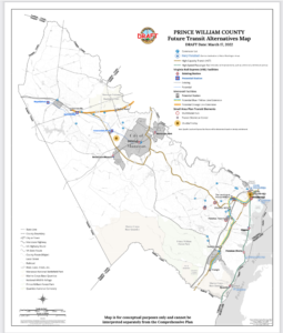
Prince William County’s Proposed “Future Transit Alternatives Map” Dated March 17, 2022

On April 15, 2022, Active Prince William submitted the following public comments on the draft “Future Transit Alternatives Map” that defines the public transportation element for the update to Prince William County’s Comprehensive Plan known as “Pathways to 2040”.


1) The Future Transit Alternatives Map needs to identify specific sites for proposed High-Capacity Transit stations that would exist by the year 2040.

The Metropolitan Washington Council of Governments needs to accept those sites on its map of High Capacity Transit Station Areas and to agree that they qualify as “Regional Activity Centers” (using the MWCOG definition of that term), so Prince William’s 2040 Comprehensive Plan is consistent with the Metropolitan Washington Planning Framework for 2030.

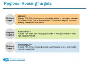
Unless specific station sites are identified, the Mobility Chapter will not be integrated with the Land Use and Housing Chapters.  Identifying the planned locations of future VRE and Metrorail stations is required for the Land Use Chapter (including Land Use Map) to specify where new Transit-Oriented Development (TOD) will be planned within walking distance of High-Capacity Transit Stations.  Identifying the planned locations of future VRE and Metrorail stations is required for the Housing Chapter to plan to meet regional housing targets set with MWCOG.

MWCOG’s Regional Housing Targets

2) The Future Transit Alternatives Map should clarify if all projects shown on the map are planned to be completed by 2040.   If some projects will have a longer time frame, then the projects planned to be completed by 2040 should be identified clearly or included on a separate map.  In particular, the proposed extensions of the Metrorail Orange Line and the VRE Manassas Line are redundant, and both are likely unnecessary with the advent of the I-66 Express Lanes.  The Future Transit Alternatives Map should clearly identify that the existing I-95 and imminent I-66 Express Lanes are “existing” High-Capacity Transitways.

Knowing what projects are expected to be built over the next 20 years is necessary so other Comprehensive Plan policies, action strategies, and projects can be budgeted and synchronized.  Maps showing planned roads and trails should also identify projects planned for completion by 2040, plus other aspirational projects using the same approach for transit projects.

3) The Mobility Chapter should include action strategies to acquire right-of-way for the proposed route of the Orange Line to Gainesville or that project should be removed from the map.  Unless located within the I-66 right of way, the right-of-way for the Orange Line extension may require going through Bull Run Regional Park, Manassas National Battlefield Park, and/or high-value commercial properties.  Fairfax County committed almost $60 million to preserve right-of-way along the I-66 corridor for extending Orange Line to Centerville during expansion to create Express Mobility Partners toll lanes, but Prince William preserved no right-of-way–suggesting a proposal for extending the Orange Line to Gainesville is more of a fantasy than an actual plan.

4) If the proposed route of the Orange Line to Gainesville remains on Future Transit Alternatives Map , then the Land Use Chapter should include plans for town centers with T-5 and T-6 Transect Zones at the station locations.

5) The Mobility Chapter should define the southern terminus of the proposed Blue/Yellow Line in eastern Prince William, and that terminus should subsequently be identified in the Visualize 2045, TransAction, and VTrans plans.

6) The Mobility Chapter should include action strategies to acquire right-of-way for the proposed route of the Blue/Yellow Line to Triangle or of the proposed BRT system.

7) The proposed route of the Blue/Yellow Line to Triangle , or of the proposed BRT system, should be clarified so it will be clear what land parcels will be suitable for Transit-Oriented Development.  In particular, it should be clear if the large Potomac Mills site will have a High-Capacity Transit station at one edge, because portions of that property could end up more than one-half mile from a station.

8) The Quartz development at the intersection of Minnieville Road and Prince William Parkway, and the intersection of Dale Boulevard-Minnieville Road should not be designated as “MultiMobile Hubs” if those sites will not have a High-Capacity Transit station.  Bus stops with commuter lots technically might be “multimobile,” but should not be planned for the same level of development as sites with a High-Capacity Transit station.

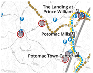
Proposed “Future Transit Alternatives” for Eastern Prince William County

9) Plans for town centers with T-5 and T-6 Transect Zones should be included in the Land Use Map for all sites in eastern Prince William where a High-Capacity Transit station is planned.

10) Action strategies in the Mobility Chapter should identify how to obtain local, state, and Federal funding for extension of Metrorail to Prince William, creation of a Bus Rapid Transit system and shuttle/trolley systems, and development of infrastructure for the proposed commuter ferry.

11) The Land Use Map should identify where affordable housing is planned within walking distance of planned High-Capacity Transit stations, in order to meet the MWCOG targets.  Families are cost-burdened if housing costs exceed 30% of Area Median Income, but also cost-burdened if housing and transportation costs combined exceed 42% of Area Median Income.

12) The 2040 Comprehensive Plan should quantify the shortage of affordable housing units for families earning 30%, 50%, and 80% of Area Median Income now, and the projected shortage in 2030 and 2040.  The Land Use Map should identify where new affordable housing will be developed by 2030 and 2040 to eliminate the shortage of affordable housing in those three categories, and those locations for new affordable housing should be planned within walking distance of High-Capacity Transit stations.

13) More-detailed shuttle/trolley routes and boundaries of areas where service is planned should be identified on the Future Transit Alternatives Map.  The Mobility Chapter should include an action strategy to complete and update regularly origin and destination studies for proposed shuttle/trolley routes, in order to integrate the Mobility Chapter with other 2040 Comprehensive Plan chapters and with the Comprehensive Plans in the Cities of Manassas and Manassas Park. Shuttle/trolley routes should be structured to connect Activity Centers as defined by MWCOG and also nodes of existing/planned dense development as shown on the Land Use Map.

14) An action strategy should be included in the Mobility Chapter to identify the year when shuttle/trolley service will become operational, so rezonings and construction plans can be synchronized.

15) If “[s]pecific objectives include adapting to changing mobility trends, improving multi-modal options, increasing the use of public transit, increasing travel time reliability while concurrently striving to decrease the use of vehicle fuels that contribute to climate change,” then the Mobility Chapter needs to add Local and Express Bus Service maps showing areas to be served by bus service and the stages in which that service will be expanded over the next 20 years.  Upgrading local bus service to facilitate access to local jobs, schools, healthcare, retail, and other key destinations for less-advantaged households is at least as essential as extending commuter rail routes that carry white-collar workers out of Prince William. Upgrading low-cost local transit and upgrading bike/pedestrian access offers the greatest opportunity to invest in upgrading equity.  Fairfax Connector Transit Strategic Plan Update offers an understandable format that can be used to support comprehensive plan update effort

16) “High-Capacity Transit”, as identified on this map, should be adequately defined in terms of weekday boardings, peak-period headways, and service hours.  Bus service that operates for fewer than 16 hours on weekdays, has peak-period headways longer than 15 or 20 minutes, or experiences fewer than 500 daily boardings is merely ordinary transit service.

17) The “High-Capacity Transit” lines in the western part of the county, which lack connections to Downtown Manassas, the Manassas Park City Center, the Godwin Drive Technology Corridor, and Sudley Road/Route 234 Business, are missed opportunities.  Recommend coordinating with Omniride which represents the entire Greater Manassas area.

###

PWC Seeks Public Feedback on Its Proposed Trails Element for Its Comp Plan Update

Prince William County government emailed the following public notice on November 24, 2021.  Active Prince William encourages all active mobility and trail advocates to carefully review this Interactive Trails Comment Map for omissions and deficiencies and to submit specific feedback using the built-in comment feature.

An interactive Trails Comment Map is now available as part of the Pathway to 2040 Comprehensive Plan Update to the Non-Motorized section of the Mobility Chapter.

The map is intended to gather comments about the future of the trail system and not about existing trail conditions or maintenance and facilities issues.

Please leave comments about where you think there should be a trail or where there is a gap in the trail and sidewalk system.

The Planning Office, Department of Transportation, and Department of Parks, Recreation, and Tourism would like as much feedback as possible regarding this topic so please pass this information along to as many people as you like.

Comments will be reviewed and considered for inclusion in the plan update. No identifiable information included in the Comment form will be shown on the map and will only be made available if a FOIA request is submitted.

Interactive Trails Comment Map

Pathway to 2040 Mobility Chapter web page

« Older posts